Butler's party
Item
Brown, William J, “Butler's party”, Surveyor General's Office, Cory Library and Historical Archives, accessed 28 December 2025, https://digitalarchives.ru.ac.za/s/cory/item/10967
- Title
- Butler's party
- Description
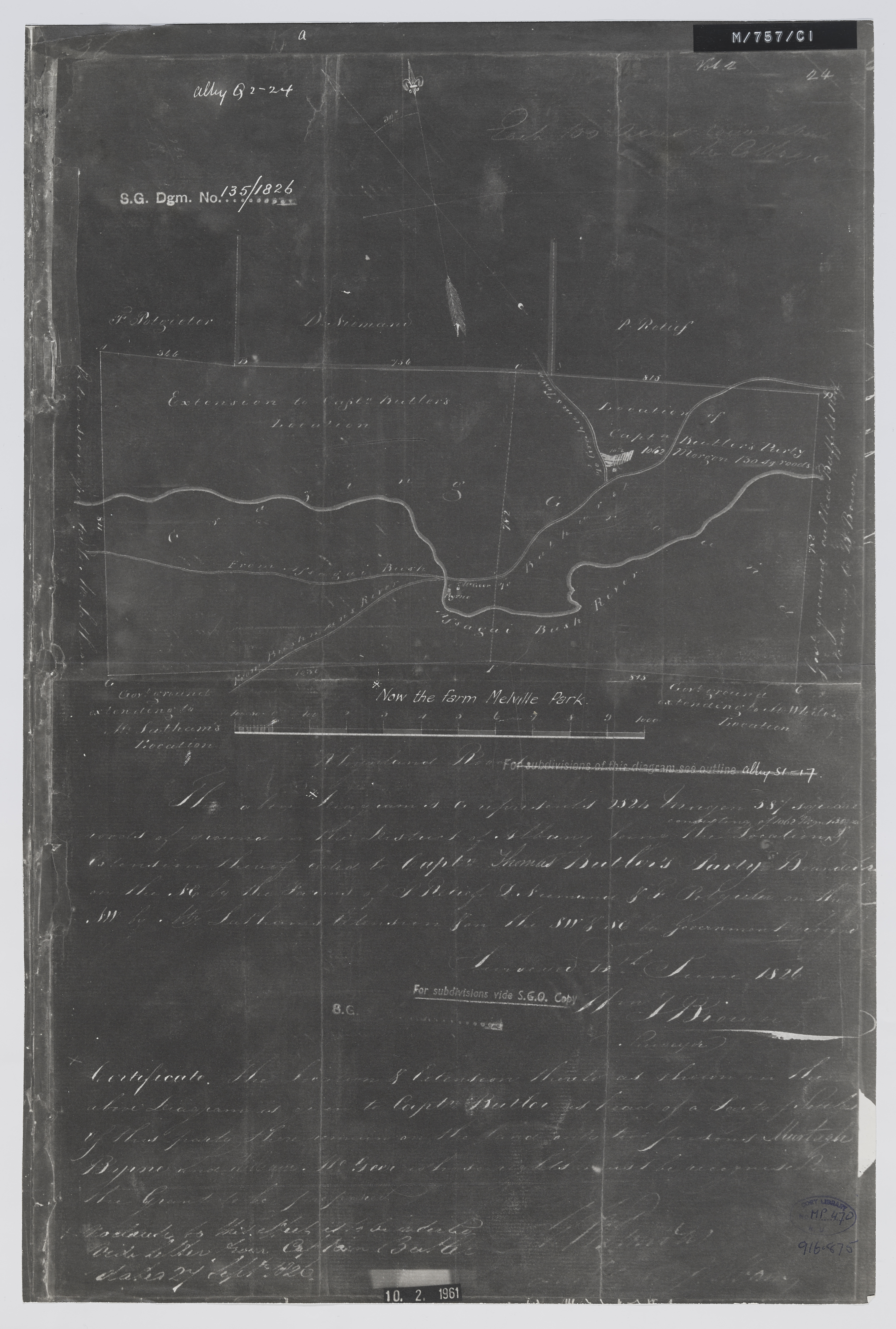
- Diagram of the location … and extension thereof ceded to Capt. Thomas Butler's party, now the farm Melville Park, in the district of Albany; surveyed 13th June 1826 [by] Wm. J. Brown. Photo negative.
- Creator
- Brown, William J
- Publisher
- Surveyor General's Office
- Date Issued
- 1961
- Cartographics - Scale
- 1 inch = 200 Rhynland roods
- Subject
- British settlers of 1820 (South Africa) -- Maps
- South Africa -- History -- 1806-1910 -- Maps
- Type
- cartographic
- Genre
- maps
- Format
- jpg
- Extent
- 1 sheet, 46 cm x 31 cm
- Language
- English
- Rights Holder
- Brown, William J
- Location - Physical Location
- Original held at Cory Library for Humanities Research, situated at Rhodes University.
- Identifier
- http://hdl.handle.net/10962/109569
- Location - Copy -- Shelf Locator
- MP468.470
- useGuidelines
- Public Domain
- Hierarchies
-
Cory Map Collection
- Pre 1910 Maps (95 items)
- 1910 - pre-1994 Maps (119 items)
- The 1820-Settlers (32 items)
- The Frontier Wars (92 items)
- The Development of Settler Towns (468 items)
- Alice (40 items)
- Bathurst (16 items)
- Bedford (3 items)
- Cathcart (5 items)
- Cradock (200 items)
- East London (22 items)
- Grahamstown (91 items)
- King William's Town (32 items)
- Port Alfred (19 items)
- Port Elizabeth (34 items)
- Queenstown (6 items)
Brown, William J, “Butler's party”, Surveyor General's Office, Cory Library and Historical Archives, accessed 28 December 2025, https://digitalarchives.ru.ac.za/s/cory/item/10967
New Tags
Position: 880 (1 views)

