Pre 1910 Maps
Item set
- Title
- Pre 1910 Maps
- Alternative Title
- Cory Library Historical Map Collection
- Description
-
This digital collection comprises 95 historical maps and plans created before 1910, drawn from the cartographic holdings of the Cory Library for Humanities Research at Rhodes University. The maps encompass a range of colonial-era topographic surveys, military sketches, regional cartographic representations, and early colonial settlement plans, covering parts of Southern Africa, particularly the Eastern Cape, Cape Colony, and adjacent territories. The collection includes manuscript plans and lithographed maps, many of which were compiled under the auspices of colonial government departments, military engineers, and early surveyors. It reflects early geographical knowledge and spatial organisation during the 19th century and the period just before the turn of the 20th century, including maps of military engagements (e.g., Spion Kop, 1900), indigenous territories, settlement expansions, and early infrastructural landscapes.
digitalarchives.ru.ac.za
These pre-1910 maps are vital resources for historians, geographers, archaeologists, and researchers interested in colonial cartography, frontier history, military history, settlement patterns, indigenous landscapes and early colonial administration in South Africa. Each map provides unique insights into historical spatial understandings and territorial control at a formative stage in South African cartographic history. - Language
- English
- Type
- Collection
- Format
- Digital Images (various scans) - Various map scales and projections
- Spatial Coverage
- Southern Africa (includes Cape Colony divisions, Transkei, Natal region, etc.)
- Temporal Coverage
- 19th century – very early 20th century (pre-1910)
- Relation
- Part of the Cory Map Collection; Related to other map sets such as 1910-pre-1994 Maps
- Extent
- 95 map items (digital)
Items
-
 Surveyed by T. Knobel, 1821.
 -
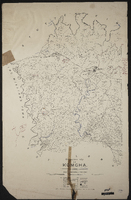
 Diagrams and/or survayor's descriptions of the farms: Springvale, Proctor's Fontein, Komga, Boekenhoud Fontein (Petrus de Wit J. Wilmot), Assegaai Bush (Johannes Potgieter), Klip Fontein, Carel's Rust (Nics. Niemand), Latham's Farm (Joseph Latham), Matjes Kraal, Seven Fountains, Faber's Kraal (Fred. Potgieter), Hartebeest Pad (Diedk. Niemand), Melville Park (Thos. Butler, George Slater), Sharon (T.C. White), farm of J.D.P. Francis. Negative copy of original, 1874. Signed A. de Smidt.
 -
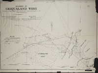 Boundary of Griqualand West (MP416d)compiled by the Surveyor General's records from the surveys in progress by Mr. Surveyor J.H. Ford and from personal observation. Boundary beaconed by Mr.Surveyor Ford, recommended by Colonel Mosey, and approved MM Aby. Lithographed and printed by W.A. Richards and Son, Cape Town. Plan attached to the Griqualand West Northern Boundary Commission (MP416e), dated June 21, 1883 ; Boundary recommended the lines ST and TU, S. Melvill, 4th July 1883.
 -
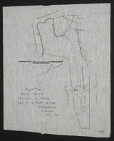
 Diagram of the location … and extension thereof ceded to Capt. Thomas Butler's party, now the farm Melville Park, in the district of Albany; surveyed 13th June 1826 [by] Wm. J. Brown. Photo negative.
 -
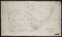 Cape of Good Hope; by J[ohn] Arrowsmith, [1842], possibly pusblished by J. Arrowsmith, this map is with permission copied from the original ms drawing in the Colonial Office compiled by Mr Herbert senr.
 -
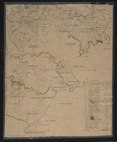
 "Fine pasture country uninhabited and considered neutral ground". Title 29th January 1944. Copied by Walter P. Jones, 21st July 1873.
 -
 Diagram of Carel's Rust in the division of Albany, field-cornetcy of Assegaai Bush, granted to Nicolaas Niemand; surveyed by Wm. J. Brown. Original date not identified. Negative photograph.
 -
-
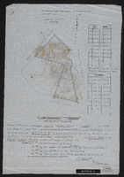 Diagram of the farm Wilton, being a portion of the farm known as Hoffman's Kloof, granted under amended title to Henry Webb and Clement John Sneyd on the 26th day of July 1897, surveyed and beaconed by me according to regulations 19th July 1910. P. Coperman. In the Division of Albany, Field Cornetcy of Lower Riebeek.
 -
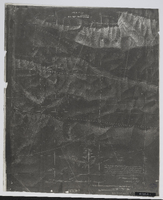
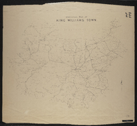
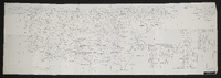 Albany sheet no. 6. Details of Sephton's party, Clarke's party, Morgan's party, Howard's party and Liversage's party.
 -
 An incomplete series of sheets in 10 sections (laminated working copy) MP 390-394.
 -
 Details of Sephton's party, Clarke's party, Morgan's party, Howard's party and Liversage's party. C. Neumann Thomas, compiler ; [Cape Town, Surveyor General's Office].
 -
 Albany sheet no. 6. Details of Sephton's party, Clarke's party, Morgan's party, Howard's party and Liversage's party.
 -
-
-

-
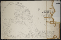 Divisional map of Vryburg, 1900, compiled by J. Fleming ; scale 2000 Cape roods = 1 inch ; 3 sheets.
 -
 Copied by Walter P. Jones, 21st July 1873. War Department number on map WD. X
 -
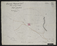
 Copied by Walter P. Jones, 23rd July 1873. War Department number on map WD. X
 -
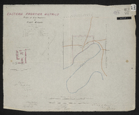 Copied by Walter P. Jones, 17th July 1873. War Department number on map WD. VII
 -
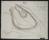
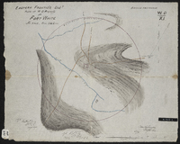
 Title 29th January 1944. Copied by Walter P. Jones, 21st August 1873. War Department number on map WD. XIII.
 -
 Copied by Walter P. Jones, 18th August 1873. War Department number on map WD. IV.
 -
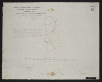
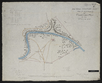
 Copied by Walter P. Jones, 23rd July 1873. War Department number on map WD. XI.
 -
 Copied by Walter P. Jones, 19th August 1873. War Department number on map WD. VI.
 -
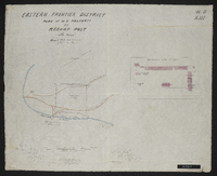 Copied by Walter P. Jones, 23rd July 1873.War Department number on map WD. XIII.