-
Date Issued
-
1867
-
Description
-
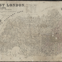
Plan of the division of East London, British Kaffraria, taken from general plans framed by D. Macdonald, A. E. Murray, E.T. Cooper, H.E.R. Bright, J.X. Merriman, J. Powell, E. Griffiths, W.D. Dumbleton, C. Watermeyer, H. Bryant, Lieutenant Colley, C.A. Smith and C.J. Gray, Government Surveyors; Compiled by C. Neumann Thomas, Surveyor General's Office, Cape Town, 1867. Scale 1" = 4000 Cape Roods. 1 sheet 30" x 72". Showing Field Cornetcy areas and Leased Lots.
-
Creator
-
Thomas, Charles Neumann, 1840-1923
-
MacDonald, D
-
Murray, A E
-
Cooper, E T
-
Bright, H E R
-
Merriman, John Xavier, 1841-1926
-
Powell, J
-
Griffiths, E
-
Dumbleton, W D
-
Watermeyer, C P
-
Bryant, H
-
Colley, George Pomeroy, Sir, 1835-1881
-
Smith, C A
-
Gray, C J
-
Scale
-
1 inch = 4000 Cape roods
-
Coordinates
-
-33.015° S 27°54′E
-
Publisher
-
Governor General's Office
-
Geographic Scope
-
East London, British Kaffraria
-
Time Span / Period
-
1860s
-
Type
-
cartographic
-
Genre
-
maps
-
Format
-
jpg
-
Extent
-
1 sheet, 30 x 72 in
-
Language
-
English
-
Rights Holder
-
Thomas, Charles Neumann, 1840-1923, MacDonald, D, Murray, A E, Cooper, E T, Bright, H E R, Merriman, John Xavier, 1841-1926, Powell, J, Griffiths, E, Dumbleton, W D, Watermeyer, C P, Bryant, H, Colley, George Pomeroy, Sir, 1835-1881, Smith, C A, Gray, C J
-
Use/Re-use
-
Public Domain
-
Archive
-
Original held at Cory Library for Humanities Research, situated at Rhodes University.
-
Asset No.
-
MP176
-
Identifier
-
http://hdl.handle.net/10962/104929
-
useGuidelines
-
Public Domain