Map of the Eastern frontier of the Cape Colony
Item
-
Date Issued
-
1856
-
Description
-
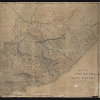
Map of the Eastern frontier of the Cape Colony, compiled by Henry Hall, a draughtsman to the Royal engineers, Cape Town, from military and other surveys, and dedicated by permission to J.F. Burgoyne. Published London, Edward Stanford.
-
Scale
-
5 inches = 30 miles
-
Publisher
-
Edward Stanford
-
Type
-
cartographic
-
Genre
-
maps
-
Format
-
jpg
-
Extent
-
1 sheet, 101 x 95 cm
-
Language
-
English
-
Rights Holder
-
Hall, Henry
-
Archive
-
Original held at Cory Library for Humanities Research, situated at Rhodes University.
-
Asset No.
-
MP534(2)
-
Identifier
-
http://hdl.handle.net/10962/106423
-
useGuidelines
-
Public Domain