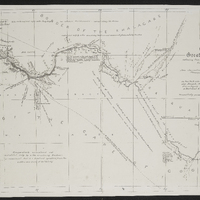
Plan of a portion of the Kei Garip or Great Orange River, extending from Eis to Pella Mission Station and forming the Northern frontier of the Colony : constructet from observations made during a journey from Little Namaqualand to Kuruman in October 1856...
Item
-
Date Issued
-
1857
-
Description
-
Respectfully presented to the Colonial Government with a memoir signed by R. Moffat Jun. .. Kuruman, Jan., 1857.
-
Type
-
cartographic
-
Genre
-
maps
-
Format
-
jpg
-
Extent
-
1 sheet, 19 x 38 in
-
Language
-
English
-
Rights Holder
-
Moffat, Robert, 1827-1862
-
Archive
-
Original held at Cory Library for Humanities Research, situated at Rhodes University.
-
Asset No.
-
MP131
-
Identifier
-
http://hdl.handle.net/10962/55456
-
useGuidelines
-
1 sheet, 19 x 38 in