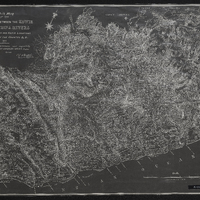
Sketch map of the country between the Kowie and the Chalumna Rivers showing the Fingo and Kafir locations, general lay of the country etc
Item

- Date Issued
- 1876
- Type
- cartographic
- Genre
- maps
- Format
- jpg
- Extent
- 1 sheet, 57 x 89 cm
- Language
- English
- Archive
- Original held at Cory Library for Humanities Research, situated at Rhodes University.
- Asset No.
- MP344
- Identifier
- http://hdl.handle.net/10962/54810
- useGuidelines
- 1 sheet, 57 x 89 cm
- Item sets
- Pre 1910 Maps