Grahamstown : average number of rooms per house, Grahamstown : a socio-ecological study of a small South African town
Item
Watts, Hilstan Lett, 1929-, “Grahamstown : average number of rooms per house, Grahamstown : a socio-ecological study of a small South African town”, Hilstan Lett Watts, Cory Library and Historical Archives, accessed 28 December 2025, https://digitalarchives.ru.ac.za/s/cory/item/10768
- Description
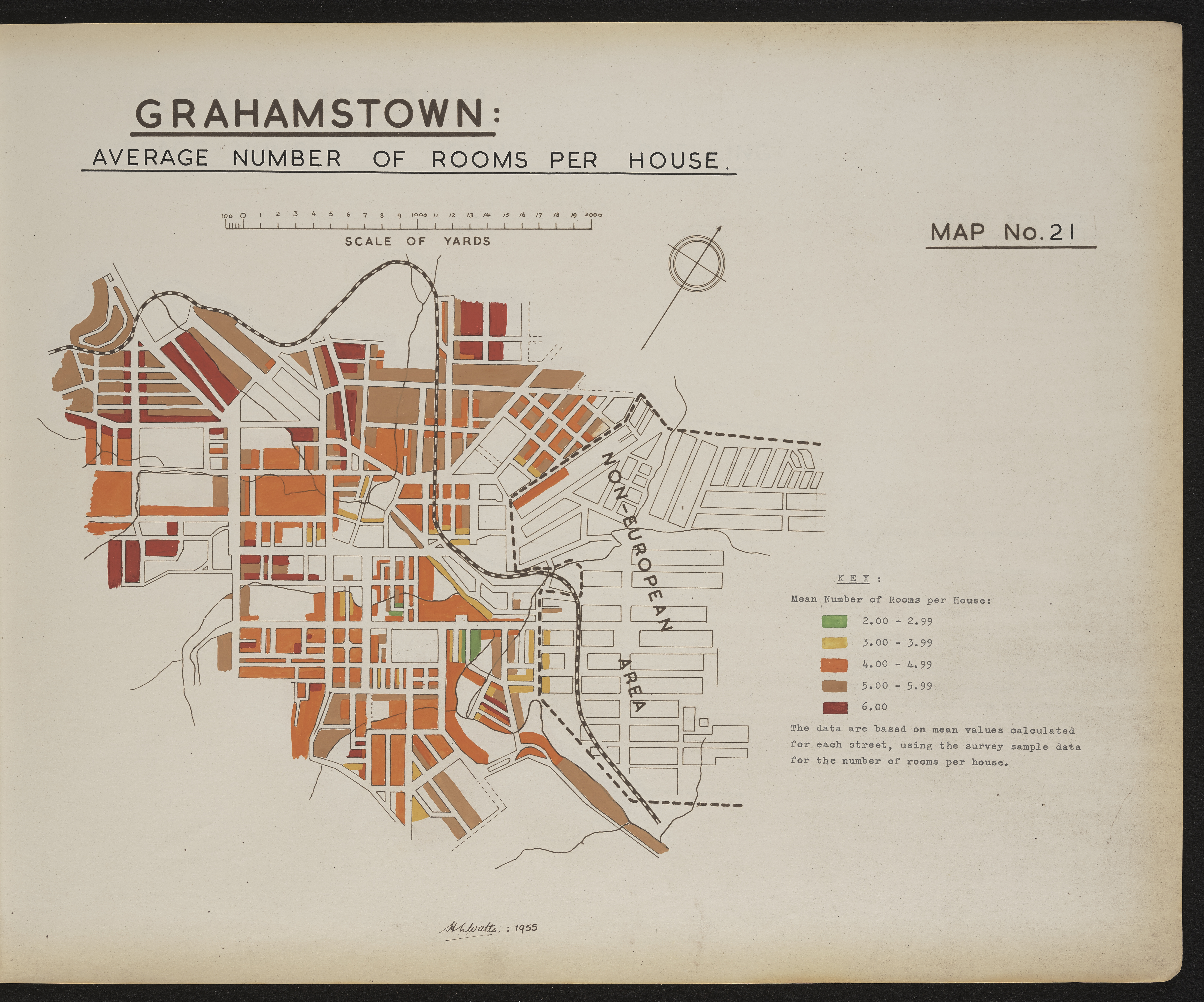
- Map 21 in the map album accompanying the thesis by Hilstan Lett Watts, "Grahamstown : a socio-ecological study of a small South African town", Rhodes University thesis, 1957. Map signed 1955. The data are based on mean values calculated for each street, using survey sample data for the number of rooms per house.
- Creator
- Watts, Hilstan Lett, 1929-
- Publisher
- Hilstan Lett Watts
- Date Issued
- 1957
- Cartographics - Scale
- 2 cm = 2000 yards
- Spatial Coverage
- 30.5595° S, 22.9375° E
- Subject
- Grahamstown (South Africa) -- Maps
- Grahamstown (South Africa) -- Street -- Maps
- South Africa -- History -- 1909-1961
- South Africa -- History -- 1836-1909
- Type
- cartographic
- Genre
- maps
- Format
- jpg
- Extent
- 1 sheet 58 x 38 cm
- Language
- English
- Rights Holder
- Watts, Hilstan Lett, 1929-
- Location - Physical Location
- Original held at Cory Library for Humanities Research, situated at Rhodes University.
- Identifier
- http://hdl.handle.net/10962/121271
- Location - Copy -- Shelf Locator
- T654_21
- Item sets
- 1910 - pre-1994 Map Collection
- Hierarchies
-
Cory Map Collection
- Pre 1910 Maps (95 items)
- 1910 - pre-1994 Maps (119 items)
Watts, Hilstan Lett, 1929-, “Grahamstown : average number of rooms per house, Grahamstown : a socio-ecological study of a small South African town”, Hilstan Lett Watts, Cory Library and Historical Archives, accessed 28 December 2025, https://digitalarchives.ru.ac.za/s/cory/item/10768
New Tags
Not viewed

