Items
-
 Map 18 in the map album accompanying the thesis by Hilstan Lett Watts, "Grahamstown : a socio-ecological study of a small South African town", Rhodes University thesis, 1957. Map signed 1955. Data are based on a special survey conducted by the investigator. A complete and not a sample survey was made.
 -
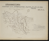 Map 24 in the map album accompanying the thesis by Hilstan Lett Watts, "Grahamstown : a socio-ecological study of a small South African town", Rhodes University thesis, 1957. Map signed 1955. The data are from the sample survey of the European area of Grahamstown.
 -
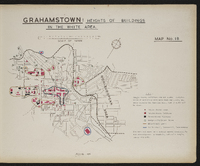
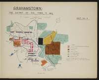
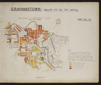
 Map 6 in the map album accompanying the thesis by Hilstan Lett Watts, "Grahamstown : a socio-ecological study of a small South African town", Rhodes University thesis, 1957. Map signed 1955.
 -
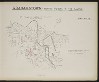
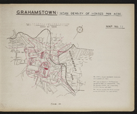 Map 11 in the map album accompanying the thesis by Hilstan Lett Watts, "Grahamstown : a socio-ecological study of a small South African town", Rhodes University thesis, 1957. This map is based on the municipal valuation roll for Grahamstown, 1953. Map signed 1955.
 -
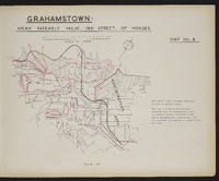 Map 8 in the map album accompanying the thesis by Hilstan Lett Watts, "Grahamstown : a socio-ecological study of a small South African town", Rhodes University thesis, 1957. Map signed 1955. This map is based on the Municipal Valuation Roll for Grahamstown, 1953. The rateable values are based on mean values calculated for each street. The map represents parameters as sampling was not used.
 -
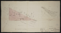 Grahamstown : Plan showing portion of Cemetery required by S.A.R. ; plan aantonende gedeelte van begraafplek deur S.A.S. Signed by District Engineer, 26.4.54 ; System engineer 30.4.54 ; System manager 3.5.54 ; scale as shown 26.4.54 ; No PE 138, A 9.
 -
 Map 15 in the map album accompanying the thesis by Hilstan Lett Watts, "Grahamstown : a socio-ecological study of a small South African town", Rhodes University thesis, 1957. Map signed 1955. The data are from the sample survey of the European area of Grahamstown.
 -
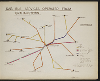 Diagram 6 in the map album accompanying the thesis by Hilstan Lett Watts, "Grahamstown : a socio-ecological study of a small South African town", Rhodes University thesis, 1957. Map signed 1955. This diagram is based on a S.A.R. diagram and is not to scale. Bus service frequencies are for scheduled regular services only and are taken from the 1953 S.A.R. timetable (no. 150, 15th June 1953).
 -
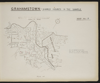 Map 17 in the map album accompanying the thesis by Hilstan Lett Watts, "Grahamstown : a socio-ecological study of a small South African town", Rhodes University thesis, 1957. Map signed 1955. Data are from a sample survey of the European area of Grahamstown.
 -
 Map 9 in the map album accompanying the thesis by Hilstan Lett Watts, "Grahamstown : a socio-ecological study of a small South African town", Rhodes University thesis, 1957. Map signed 1955. Data obtained from the Department of Social Welfare's Office in Grahamstown, and school records of the Cape Provincial Education Department ; also from the Magistrate's Court records.
 -
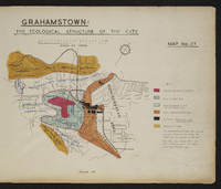 Map 27 in the map album accompanying the thesis by Hilstan Lett Watts, "Grahamstown : a socio-ecological study of a small South African town", Rhodes University thesis, 1957. Map signed 1955.
 -
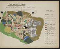
 Map 3 in the map album accompanying the thesis by Hilstan Lett Watts, "Grahamstown : a socio-ecological study of a small South African town", Rhodes University thesis, 1957. Map signed 1955. Based on an original map in the Cory Library, Rhodes University.
 -
 Map 20 in the map album accompanying the thesis by Hilstan Lett Watts, "Grahamstown : a socio-ecological study of a small South African town", Rhodes University thesis, 1957. Map signed 1955. The data are from the sample survey of the European area of Grahamstown.
 -
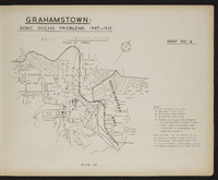
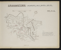 Map 10 in the map album accompanying the thesis by Hilstan Lett Watts, "Grahamstown : a socio-ecological study of a small South African town", Rhodes University thesis, 1957. Map signed 1955. The map represents the total number of unemployed male whites registered with the Labour Office in Grahamstown during 1947-1951.
 -
 Grahamstown and surrounding farms compiled from diagrams annexed to their respective grants in the Surveyor-General's Office; by D. Kryndow. Copy of original manuscript.
 -
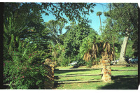 Varied vegetation. Gardens date from 1853.
 -
 Added to the lantern slide collection by Dr Charles GE Cory, son of Sir George Cory.
 -
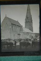 Ox wagons and oxen teams in the foreground.
 -
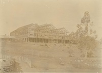
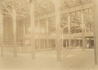 Photograph album : assembled and donated by L.A. Hewson / photographer/s mostly unknown. Donated by L.A. Hewson (Deposit 154)
 -
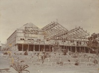
 Photograph album : assembled and donated by L.A. Hewson / photographer/s mostly unknown. Donated by L.A. Hewson (Deposit 154)
 -
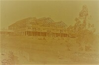
 Photograph album : assembled and donated by L.A. Hewson / photographer/s mostly unknown. Donated by L.A. Hewson (Deposit 154)
 -
 Photograph album : assembled and donated by L.A. Hewson / photographer/s mostly unknown. Donated by L.A. Hewson (Deposit 154)
 -
 Photograph album : assembled and donated by L.A. Hewson / photographer/s mostly unknown. Donated by L.A. Hewson (Deposit 154)
 -
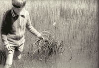 Close-up of first flowering vlei lilies, Crinum campanulatum. Planted there in 1960's by Lou Mullins.
 -
 Added to the lantern slide collection by Dr Charles GE Cory, son of Sir George Cory.