Items
-

-
-
-

-
-
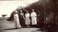
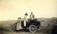
 Grace Irons sitting on the wall, Charles Butler, Dorothy, Emma and Joe Butler, Charles' brother visiting South Africa at the age of 80.
 -
-

-
-
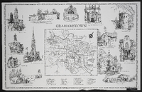 Street map of Grahamstown. This map was compiled and executed by Roy Haupt. [1965]. Printed by Cape and Transvaal Printers Ltd.
 -
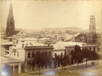
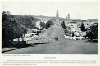 A historical landscape photograph of Grahamstown, described in the caption as one of the leading ecclesiastical and educational centres in South Africa. The view shows the Anglican Cathedral, designed by Sir Gilbert Scott, standing on high ground in the centre of the city. The Grand Hotel is visible to the right. The city is noted for being situated in an amphitheatre of wooded hills.
 -
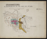 Map 7 in the map album accompanying the thesis by Hilstan Lett Watts, "Grahamstown : a socio-ecological study of a small South African town", Rhodes University thesis, 1957. Map signed 1955.
 -
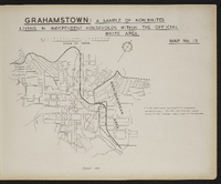
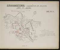
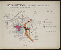 Map 12 in the map album accompanying the thesis by Hilstan Lett Watts, "Grahamstown : a socio-ecological study of a small South African town", Rhodes University thesis, 1957. Map signed 1955. The data are from the sample survey of the European area of Grahamstown.
 -
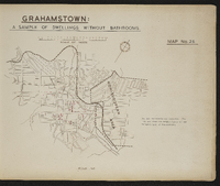
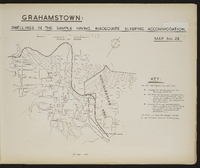
 Map 19 in the map album accompanying the thesis by Hilstan Lett Watts, "Grahamstown : a socio-ecological study of a small South African town", Rhodes University thesis, 1957. Map signed 1955. The data are from the sample survey of the European area of Grahamstown.
 -
 Map 26 in the map album accompanying the thesis by Hilstan Lett Watts, "Grahamstown : a socio-ecological study of a small South African town", Rhodes University thesis, 1957. Map signed 1955. The data are from the sample survey of the European area of Grahamstown.
 -
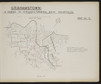
 Map 13 in the map album accompanying the thesis by Hilstan Lett Watts, "Grahamstown : a socio-ecological study of a small South African town", Rhodes University thesis, 1957. Map signed 1955. The data are from the sample survey of the European (white) area of Grahamstown.
 -
 Cover of the map album accompanying the thesis by Hilstan Lett Watts, "Grahamstown : a socio-ecological study of a small South African town", Rhodes University thesis, 1957.
 -
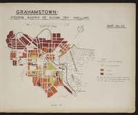 Map 22 in the map album accompanying the thesis by Hilstan Lett Watts, "Grahamstown : a socio-ecological study of a small South African town", Rhodes University thesis, 1957. Map signed 1955. The data are based on mean values calculated for each street, using survey sample data for the number of rooms per dwelling.
 -
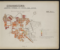 Map 21 in the map album accompanying the thesis by Hilstan Lett Watts, "Grahamstown : a socio-ecological study of a small South African town", Rhodes University thesis, 1957. Map signed 1955. The data are based on mean values calculated for each street, using survey sample data for the number of rooms per house.
 -
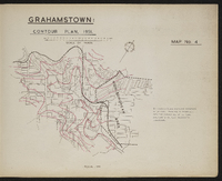 Map 4 in the map album accompanying the thesis by Hilstan Lett Watts, "Grahamstown : a socio-ecological study of a small South African town", Rhodes University thesis, 1957. Map signed 1955. This map is based on a detailed contour map of the town, prepared by the City Enginner's Department.
 -
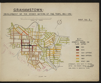 Map 2 in the map album accompanying the thesis by Hilstan Lett Watts, "Grahamstown : a socio-ecological study of a small South African town" ; Rhodes University thesis, 1957. Map signed 1955.
 -
 Map 16 in the map album accompanying the thesis by Hilstan Lett Watts, "Grahamstown : a socio-ecological study of a small South African town", Rhodes University thesis, 1957. Map signed 1955. Data are based on a special survey conducted by the investigator. A complete and not a sample survey was made.
 -
 Map 25 in the map album accompanying the thesis by Hilstan Lett Watts, "Grahamstown : a socio-ecological study of a small South African town", Rhodes University thesis, 1957. Map signed 1955. The data are from the sample survey of the European area of Grahamstown.
 -
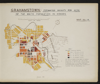 Map 14 in the map album accompanying the thesis by Hilstan Lett Watts, "Grahamstown : a socio-ecological study of a small South African town", Rhodes University thesis, 1957. Map signed 1955. The data are based on number of persons per street, estimated on the basis of the survey sample, and the total acreage covered by housing plots in the street (excluding unoccupied plots) obtained from the municipal valuation roll for Grahamstown, 1953.
 -
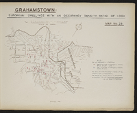 Map 23 in the map album accompanying the thesis by Hilstan Lett Watts, "Grahamstown : a socio-ecological study of a small South African town", Rhodes University thesis, 1957. Map signed 1955. The data are from the sample survey of the European area of Grahamstown