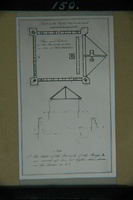
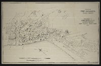
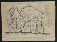
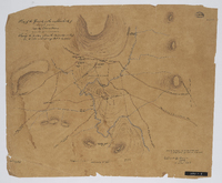
Fort Willshire was built by the Royal Engineers under Lieutenant Colonel Thomas Willshire of the 38th Regiment, on the orders of Lord Charles Somerset, in 1819.
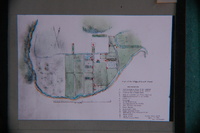
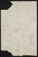
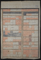
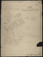
Plan of Grahamstown noting owners of erven 1 to 20 and at Cape Corps Barracks (Fort England). Duplicate of MP145. The map is unsigned and a photocopy. Given to the Cory Library by Mr. K.S. Hunt
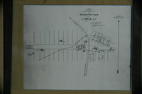
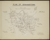
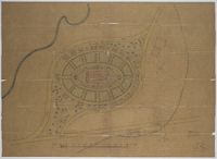
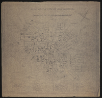
Map 1 in the map album accompanying the thesis by Hilstan Lett Watts, "Grahamstown : a socio-ecological study of a small South African town", Rhodes University thesis, 1957. Map signed 1955. This map is based on a municipal map, with necessary corrections. Street widths are exaggerated for the purpose of clarity. The street pattern shown is for the town in 1951. The so-called "Hottentot Village" is today the Coloured location.
Fort Willshire was built by the Royal Engineers under Lieutenant Colonel Thomas Willshire of the 38th Regiment, on the orders of Lord Charles Somerset, in 1819.
Fort Willshire was built by the Royal Engineers under Lieutenant Colonel Thomas Willshire of the 38th Regiment, on the orders of Lord Charles Somerset, in 1819.
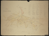
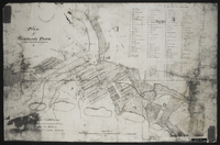
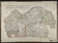
Plan of Territories formerly known as Kaffraria proper: simplified handdrawn copy of the 1884 map of the territories formerly known as Kaffraria, with additional information inserted by Alfred William Burton. Surveyors C.P. Watermeyer; Fletcher ; MacDonald, Schunke, Tilney, Norris, Greeff, Greathead, F. Watermeyer; Erskine, Hughes R.N., Changuion, Pritchard and O. Mehliss, and military sketches by Messrs Colley and Grant and the Intelligence Branch of the Quartermaster General's Department. Photocopy stuck on card. Transkeian territories. First produced in 1884 by 14 surveyors and 3 others.See MP 307, L (77) d 1 for the original map by fourteen surveyors and Military sketches.
Plan of Territories formerly known as Kaffraria proper, lying between the following boundaries, The Quathlamba range on the north, the sea coast on the east, Natal on the north east and the Kei and Indwe on south west. Compiled by plans of surveys by surveyors C.P. Watermeyer; Fletcher; MacDonald, Schunke, Tilney, Norris, Greeff, Greathead, F. Watermeyer; Erskine, Hughes R.N., Changuion, Prithcard and O. Mehliss, and military sketches by Messrs Colley & Grant & the Intelligence Branch of the Quartermaster General's Department. Includes approximate table of distances from Kokstad to several magistracies and Umtata. Map signed by A (Abraham) de Smidt, surveyor general.
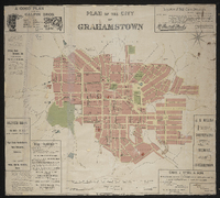
Plan of the city of Grahamstown; framed from survey and compilation in 1887 by E.D. Barker, GLS and R.S. Fairbridge GLS … by Ernest Grubb, City Engineer. "London Geographical Institute".
Plan of the City of Grahamstown, 1924 compiled in the Office of the Surveyor General, Cape Town. Compiled from plans and diagrams filed in the office of the Registrar of Deeds and Surveyor General Cape Town.
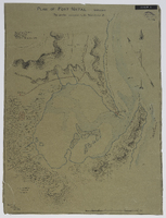
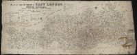
Plan of the division of East London, British Kaffraria, taken from general plans framed by D. Macdonald, A. E. Murray, E.T. Cooper, H.E.R. Bright, J.X. Merriman, J. Powell, E. Griffiths, W.D. Dumbleton, C. Watermeyer, H. Bryant, Lieutenant Colley, C.A. Smith and C.J. Gray, Government Surveyors; Compiled by C. Neumann Thomas, Surveyor General's Office, Cape Town, 1867. Scale 1" = 4000 Cape Roods. 1 sheet 30" x 72". Showing Field Cornetcy areas and Leased Lots.