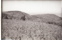
Cape and Gurney Sugerbird Promerops cafer & Gurneyi country. The left-hand dome is Hoho Peak, or Pirie West Peak, on the western slopes of which both species where found occupying and nesting in a thicket of tall, dense Protea subvestita, almost the last patch of any size on these mountains. The dark areas on the slopes are protea trees. Those on top had been burned out. Such thickets would have been more widespread in the past. Below are some Protea multibracteata plants. The thickets of subvestita were burnt out in the late 1960's to make way for stock grazing.
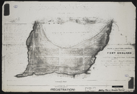
Plan of a section of ground situated between Fort England and the property of Mr John Carlisle, shewing its subdivision into allotments form actual survey executed by order of Government in the months of January and February 1857…
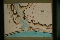
Plan of the Baakens River Mouth area with the following inscription: Plan van het Etablisement aan de Algoa-Baai. A. het Fort Frederik. B. het Blokhuis. C. Water-plaats. D. Een Wel.