-
3227CD King William's Town, King William's Town 3227CD, South Africa 1:50000 sheet, Suid Afrika 1:50000 vel 3227CD King William's Town, South Africa 1:50000 sheet. Air photography 1964. Surveyed in 1971 and drawn in 1972 by the Trigonometrical Survey Office. Lugfotografie 1964. Opgemeet in 1971 en geteken in 1972 deur die Driehoeksmeting Kantoor. T.S.O. 200/5493. Kadastrale inligting verskaf deur die Landmeter, Kaap. Second edition,Second edition
-
Below Laing Dam on the Buffalo River, King William's Town Curtain-like branches of spekboom hanging in front of a cavemouth.
-
Below Laing Dam on the Buffalo River, King William's Town Curtain-like branches of spekboom hanging in front of a cavemouth.
-
Buffalo River Valley near King William's Town, Ciskei Acacia karroo trees in full flower.
-
Cape and Gurney's Sugerbird habitat, Hoho Peak, Pirie Mountain, King William's Town, Ciskei, 1402 m asl 
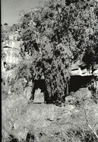
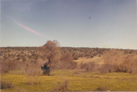
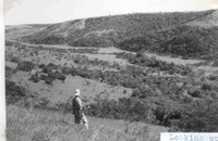
Looking westwards from top of Hoho Peak (Pirie West Peak) over Protea thickets in immediate foreground to the mid-picture ridge covered in Cliffortia fynbos and which might once have held dense Protea subvestita and /or Protea multibracteata thickets. Some of the latter still growing below the subvestita thickets there. iNtaba knNdoda Peak in distance.
-
Divisional map of King William's Town
-
Eastern Frontier District : King William's Town : general plan of W.D. property,Eastern Frontier District : King William's Town : general plan of War Department property War Department number on map WD. II
-
Hanover, King William's Town, Ciskei Dense Typha beds surrounding a vlei, used annually as a nesting site by Red Bishop birds.
-
Hepper's house, King William's Town, South Africa 
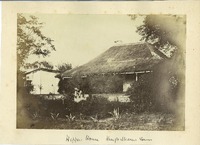
View of a man seated on the step of a thatched house in an overgrown garden, reading a newspaper. An inscription on the mount reads: 'Hepper's house, King William's Town'.
-
Immediately to the north of King William's Town and beside the Buffalo River Field of forbs (Asteracae), scattered Combretum trees surrounding.
-
King William's Town Figure points to bush where nest was built.
-
King William's Town Field of Gazania.
-
King William's Town 9 different centres from the same field of Gazania.
-
King William's Town Note the variable centre.
-
King William's Town in 1862
-
King William's Town,cartographic [Imperial map of South Africa] : Kingwilliamstown compiled by the [British Military] Intelligence Department, 1900?
-
King Williams Town
-
Land Grants 
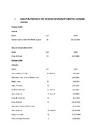
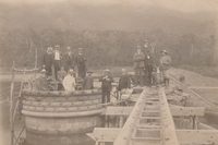
A collection of Land Grants (both Freehold and Perpetual Quitrent) and transfers/title deeds for the Stutterheim/King William's Town area. Although these are predominantly in the names of German immigrants and British German Legion settlers, there are also some grants in Freehold for Xhosa people, as well as grants in Perpetual Quitrent for men at the mission stations of Bethel, Umgwali and Wartburg. Most of the documents are accompanied by diagrams of the land in question.
-
Looking down on the lower reaches of uMthaleni Valley, Kei Road, King William's Town The Scaly-throated Honeyguides call-site was in the dense tall patch in the stream bed.
-
Looking up the uMthaleni Valley, Kei Road, King William's Town The Scaly-throated Honeyguide ranged over the whole area but mostly in the forests and along bushy streams.
-
Mayor and Councillors of King William's Town at Maden Dam, 1908 - 1910
-
Mayor and Councillors of King William's Town at Maden Dam, 1908 - 1910
-
Northfacing slope down to the Buffalo River, 5 km north of King William's Town, Ciskei 
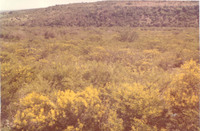
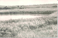
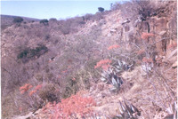
Coral Aloes Aloe striata. Much of this hillside was covered with them but the dryness of the grass hides their redness in the picture. Many sunbirds were active at the time the photo was taken.
-
Pirie Mountain, King William's Town 
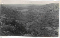
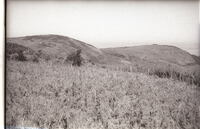
Cape and Gurney Sugerbird Promerops cafer & Gurneyi country. The left-hand dome is Hoho Peak, or Pirie West Peak, on the western slopes of which both species where found occupying and nesting in a thicket of tall, dense Protea subvestita, almost the last patch of any size on these mountains. The dark areas on the slopes are protea trees. Those on top had been burned out. Such thickets would have been more widespread in the past. Below are some Protea multibracteata plants. The thickets of subvestita were burnt out in the late 1960's to make way for stock grazing.
-
Plan shewing military defences of King Williams Town Plan shewing military defences of King Williams Town; [by] Geo. Newey.