Cathcart, Eastern Cape, South Africa
Item set
- Alternative Title
- Cathcart, Cape Colony
- Description
- The Cathcart collection is part of The Frontier Collection held and made accessible by the Cory Library and Historical Archives within the Rhodes University Digital Archives. It documents historical resources relating to Cathcart, a small town in the Eastern Cape, South Africa, within the broader scope of frontier history and the development of settler towns. As part of the Development of Settler Towns series, the collection presents images and archival materials that reflect the town’s historical character and its place in the colonial frontier landscape of the Eastern Cape. Through photographs and other items, researchers gain insight into local built heritage, settlement patterns, and social life. This collection supports historical, social, and cultural research on frontier towns established during the 19th century and contributes to preserving local heritage.
- Language
- English
- Type
- Collection
- Spatial Coverage
- Cathcart, Eastern Cape, South Africa
- Temporal Coverage
- Primarily 19th–early 20th century
- Format
- Digital images
Items
-
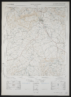 3227AC Cathcart, South Africa 1:50000 sheet. Air photography 1956. Surveyed and drawn in 1963 by the Trigonometrical Survey Office. T.S.O. 200/2021.
 -
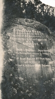 The inscription reads: “Boma Pass Road constructed December 1853 by order of His Excellency L’Gen. the Hon. Sir Geo. Cathcart K.C.B. Governor, by the Royal – Engineer Department. The working party consisted of Detachments of the 8th Regt. And the 60th Royal Rifles. Under the direction of Lieut HR Siborne Royal Engineers.
 -
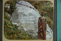 The wording on the stone is as follows – Boma Pass Road constructed December 1853 by order of His Excellency Lt. Gen. the Hon. Sir Geo. Cathcart KCB Governor, by the Royal Engineer Department. The working party consisted of Detachments of the 6th Royal Regt. and 60th Royal Rifles under the direction of Lieut. HR Siborne, Royal Engineers.
 -
-
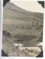 Hamerkop in a stream below Gaika's Kop.