Bathurst, Eastern Cape, South Africa
Item set
- Alternative Title
- Bathurst, Cape Colony
- Description
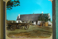
- The Bathurst, Eastern Cape, South Africa collection is a curated set of digitised historical resources held by the Cory Library and Historical Archives at Rhodes University. It documents the town of Bathurst in the Eastern Cape province of South Africa, including visual and cartographic materials that illustrate the town’s landscape, architecture, and historical development within the broader context of Eastern Cape frontier history. The items span the early settlement and colonial periods, including aerial views, architectural photographs (such as those of St. John’s Church, built in 1832), historical plans and maps of the town, and images of notable local features like Round Hill and old settler houses. This collection contributes to understanding the patterns of settlement, religious and civic infrastructure, and geographical context of a key 19th century colonial town on the Albany frontier. The collection sits within the Frontier Collection and contributes to research on settler town development, local history, and material culture in the Eastern Cape.
- Language
- English
- Type
- Collection
- Subject
- Bathurst (South Africa)
- Eastern Cape, South Africa -- History
- Settler towns -- South Africa
- St. John’s Church, Bathurst
- Cape Colony
- British settlers of 1820 (South Africa)See all item sets with this value
- Spatial Coverage
- Bathurst, Eastern Cape, South Africa
- Temporal Coverage
- Primarily 19th and early 20th centuries
- Format
- Digital images
- Maps
Items
-
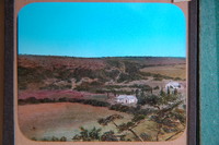
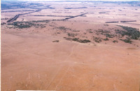
 Aerial view of Bathurst suurveld, the old Zuure Veldt, looking north to Kap River Hills with the dome of Round Hill centrally.
 -
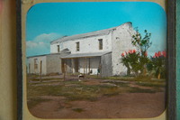
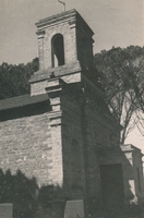
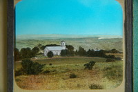 St. John's Church (Bathurst), built 1832.
 -
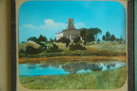 St. John's Church (Bathurst), built 1832.
 -
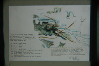
 "Fine pasture country uninhabited and considered neutral ground". Title 29th January 1944. Copied by Walter P. Jones, 21st July 1873.
 -
-
-
-
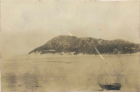 Vegetated dune-hill showing mature vegetation there in 1926 before Kenton-on-Sea was built up. Taken by C.J.Skead in 1926 when a schoolboy at St. Andrews College. He and a party of friends walked stark naked from here along the beach to Bushman's River Mount without fear of being seen by a soul.
 -
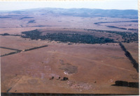
 Surrounded by Bathurst suurveld. Taken from western side.
 -
 Surrounded by Bathurst suurveld. Taken from north facing towards the coast.
 -
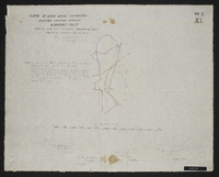
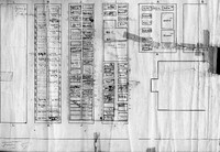 Plan of Church graveyard
 -
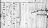 Plan of Church graveyard
 -
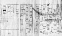 Plan of Church graveyard
 -
 "Fine pasture country uninhabited and considered neutral ground".
 -
-