Alice, Eastern Cape, South Africa
Item set
- Alternative Title
- Alice, Cape Colony
- Description
-
The Alice (Eastern Cape) Collection is a thematic digital grouping within the Cory Library and Historical Archives that documents the historical development of the town of Alice and its surrounding area in the Eastern Cape, South Africa. The collection brings together visual, cartographic, and documentary materials illustrating Alice’s origins as a frontier settlement, its growth as an administrative and educational centre, and its role within the broader colonial and mission landscape of the Eastern Cape.
Materials in this collection reflect key aspects of Alice’s history, including settler and missionary activity, frontier conflict and military presence, town planning and infrastructure, and the social and cultural life of the area. The collection also provides contextual insight into Alice’s close associations with nearby mission institutions and later educational establishments, making it a valuable resource for research into local history, frontier studies, colonial urban development, and Eastern Cape heritage. - Genre
- Archival documents
- Historical photographs
- Maps and plans
- Subject
- Alice (Eastern Cape, South Africa) — History
- Eastern Cape — Colonial history
- Mission stations — Eastern Cape
- Frontier history — Eastern Cape
- Settlements — South Africa — History
- Temporal Coverage
- 19th–20th centuries
- Spatial Coverage
- Alice (Eastern Cape, South Africa)
Items
-
-
 3226DD Alice, South Africa 1:50000 sheet. Air photography 1949. Surveyed in 1956 and drawn in 1960 by the Trigonometric Survey Office. T.S.O. 200/1471. (Lugfotogafie 1949, Opgemeet in 1956 en geteken in 1960 deur die Driehokesmatings Kantoor.) First edition.
 -
 3226AC Alicedale South Africa 1:50000 sheet. Air photography 1957. Field survey 1962. Drawn by the Trigonometric Survey in 1963. T.S.O. 200/1893. (Lugfotografie 1957. Veldopmeting 1962. Saamgestel en geteken in 1963 deur die Driehokesmatings Kantoor.) First edition
 -
 In P E Raper's "New Dictionary of South African Place Names", ISBN 1868421902, is this entry, on page 105: *Fort Willshire - Former fort at the confluence of the Keiskamma and Rhwantsana Rivers, 23km south-south-east of Alice, at 32 59S, 26 55E. It was named in honour of Lieutenant-Colonel Thomas Willshire, veteran of the Peninsular War, who took command in 1819.
 -
-
-
-
-
-
-
-
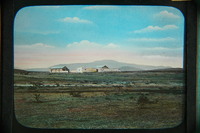
 Fort Willshire was built by the Royal Engineers under Lieutenant Colonel Thomas Willshire of the 38th Regiment, on the orders of Lord Charles Somerset, in 1819.
 -
 Fort Willshire was built by the Royal Engineers under Lieutenant Colonel Thomas Willshire of the 38th Regiment, on the orders of Lord Charles Somerset, in 1819.
 -
-
 Named after Lt.-Col. RT Thomson of the Royal Engineers.
 -
 Fort Willshire was built by the Royal Engineers under Lieutenant Colonel Thomas Willshire of the 38th Regiment, on the orders of Lord Charles Somerset, in 1819.
 -
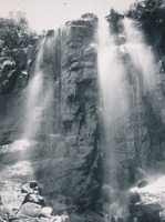
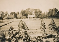
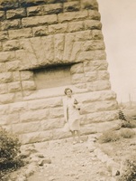
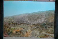
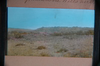
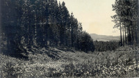 Spread of Zantedeschia aethiopica in damp hollow between pine plantations. Buttresses of southern Hogsback peak in distance.
 -

-

-
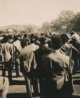
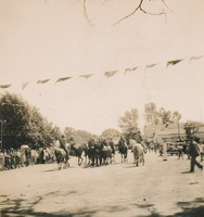
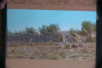
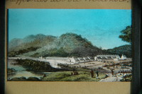 Fort Willshire was built by the Royal Engineers under Lieutenant Colonel Thomas Willshire of the 38th Regiment, on the orders of Lord Charles Somerset, in 1819.,From 1824 – 1830 weekly trade fairs were held at the Fort, where licensed British Settlers could trade in ivory, hides etc with Xhosa. At first cattle could not be traded, and trade in fire-arms and liquor was forbidden.
 -
-
-
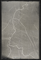 Plan of land around Lovedale; some of it marked for "alienation" - owners of some property shown. (Negative) Photograph of origincal manuscript, 1875.
 -
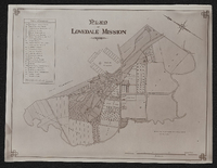 Plan of Lovedale Mission 1902. Photograph.
 -