The Development of Settler Towns
Item set
- Alternative Title
- Eastern Cape Settler Towns Historical Collection
- Description
- The Development of Settler Towns is a major digitised archival collection from the Cory Library and Historical Archives at Rhodes University, forming part of The Frontier Collection. It brings together nearly 468 digitised resources documenting the historical emergence, expansion, and material culture of settler towns across the Eastern Cape, South Africa during the colonial and frontier period. The collection includes sub-sets on towns such as Alice, Bathurst, Bedford, Cathcart, Cradock, East London, Grahamstown, King William’s Town, Port Alfred, Port Elizabeth, Queenstown and others, illustrating a range of urban development patterns, community activities, built environments, maps, plans, and visual materials that reflect the social, economic, and geographic histories of these settlements. As an overarching thematic grouping within the Cory Library’s frontier history holdings, this item set supports comparative and place-based research into settler town origins, colonial infrastructure, demographic change, and regional interactions in the Eastern Cape.
- Language
- English
- Type
- Collection
- Spatial Coverage
- Eastern Cape, South Africa (multiple towns)
- Temporal Coverage
- Primarily 19th – early 20th century
- Format
- Digital images
- Maps
Items
-
-
-
 View of the Old Deanery and the Diocesan office in High Street, on the site of the current St. George's Chambers.
 -
-
 Eastern Districts court.
 -
-
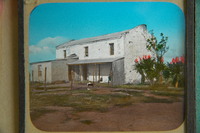
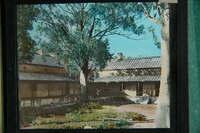 The courtyard within the old Military Hospital and part of the verandah surrounding it. This building was known for many years as the Schonland Botanical Laboratory and today still forms part of the Botany Department of Rhodes University.
 -
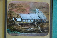
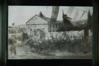
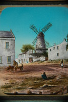 Painting showing the Old Mill on the corner of George and Market Streets, and on the left corner, the home of Mr George Wood, first Mayor of Grahamstown. The small cart was used to carry Miss Josie Wood (founder of the South African Library for the Blind) to school.
 -
-
-
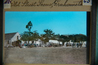 View showing the south side of upper High Street, from "Charles Pote's Auction Rooms" on the corner of Hill Street, as far as Hayton's Building. Trees, an ox wagon and people obscure the buildings.
 -
 View showing the south side of upper High Street, from "Charles Pote's Auction Rooms" on the corner of Hill Street, as far as Hayton's Building. Trees, an ox wagon and people obscure the buildings.
 -
-
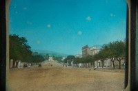
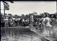
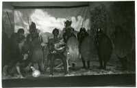
 Showing the opening of the only Parliamentary session ever held away from Cape Town.
 -
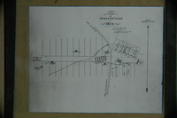
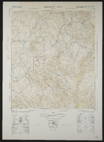 Palingkloof 3226AA. South Africa 1:50000 sheet. Air photography 1943. Field survey 1945. Drawn by the Trigonometric Survey in 1953. T.S.O. 200/1048. (Lugfotografie 1943. Veldopmeting 1945. Saamgestel en geteken in 1953 deur die Driehokesmatings Kantoor.) First edition
 -
-
-
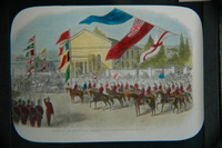
 Showing the opening of the only Parliamentary session ever held away from Cape Town.
 -
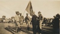 A photograph album compiled by Mary Butler, containing photographs of Wayfarers, Sunbeams and Pathfinders, mostly in Cradock. Two newspaper clippings and a handwritten concert programme included. There are three photographs of Rev. James Arthur Calata's young daughters, and he himself is included in two photographs. This photograph showing Mr A. Metcalf presenting a Pathfinder detachment flag to a group of older boys, representing Pathfinders. Standing next to him are Pathfinder officers and other people who have come to the presentation
 -
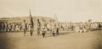 A photograph album compiled by Mary Butler, containing photographs of Wayfarers, Sunbeams and Pathfinders, mostly in Cradock. Two newspaper clippings and a handwritten concert programme included. There are three photographs of Rev. James Arthur Calata's young daughters, and he himself is included in two photographs. This photograph showing a church group of young boys, known as Pathfinders in uniform, marching and bearing a flag at a Pathfinder camp
 -
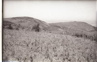 Cape and Gurney Sugerbird Promerops cafer & Gurneyi country. The left-hand dome is Hoho Peak, or Pirie West Peak, on the western slopes of which both species where found occupying and nesting in a thicket of tall, dense Protea subvestita, almost the last patch of any size on these mountains. The dark areas on the slopes are protea trees. Those on top had been burned out. Such thickets would have been more widespread in the past. Below are some Protea multibracteata plants. The thickets of subvestita were burnt out in the late 1960's to make way for stock grazing.
 -
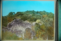
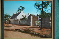
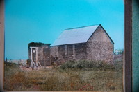
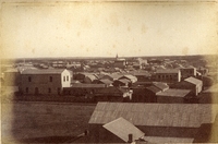
 Fort Willshire was built by the Royal Engineers under Lieutenant Colonel Thomas Willshire of the 38th Regiment, on the orders of Lord Charles Somerset, in 1819.
 -
-
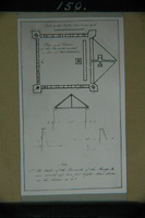
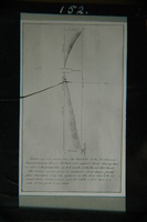
 Copy made by Sir George Cory in 1904 of a plan of Grahamstown dated 1814.
 -
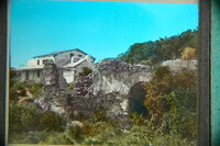
 Fort Willshire was built by the Royal Engineers under Lieutenant Colonel Thomas Willshire of the 38th Regiment, on the orders of Lord Charles Somerset, in 1819.