The Development of Settler Towns
Item set
- Alternative Title
- Eastern Cape Settler Towns Historical Collection
- Description
- The Development of Settler Towns is a major digitised archival collection from the Cory Library and Historical Archives at Rhodes University, forming part of The Frontier Collection. It brings together nearly 468 digitised resources documenting the historical emergence, expansion, and material culture of settler towns across the Eastern Cape, South Africa during the colonial and frontier period. The collection includes sub-sets on towns such as Alice, Bathurst, Bedford, Cathcart, Cradock, East London, Grahamstown, King William’s Town, Port Alfred, Port Elizabeth, Queenstown and others, illustrating a range of urban development patterns, community activities, built environments, maps, plans, and visual materials that reflect the social, economic, and geographic histories of these settlements. As an overarching thematic grouping within the Cory Library’s frontier history holdings, this item set supports comparative and place-based research into settler town origins, colonial infrastructure, demographic change, and regional interactions in the Eastern Cape.
- Language
- English
- Type
- Collection
- Spatial Coverage
- Eastern Cape, South Africa (multiple towns)
- Temporal Coverage
- Primarily 19th – early 20th century
- Format
- Digital images
- Maps
Items
-
-
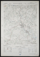
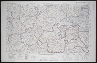 3126 Queenstown, South Africa 1:25000 sheet. Compiled and drawn in 1960 by the Trigonometric Survey Office. Magisterial districts as at March 1966. T.S.O. 404/964. (Saamgestel in 1960 en geteken in 1960 deur die Driehokesmatings Kantoor.)
 -
 3226CA Bedford, South Africa 1:50000 sheet. Air photography 1949 and 1950. Surveyed in 1965 and drawn in 1966 by the Trigonometrical Survey Office.
 -
 3226DD Alice, South Africa 1:50000 sheet. Air photography 1949. Surveyed in 1956 and drawn in 1960 by the Trigonometric Survey Office. T.S.O. 200/1471. (Lugfotogafie 1949, Opgemeet in 1956 en geteken in 1960 deur die Driehokesmatings Kantoor.) First edition.
 -
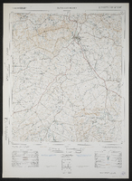 3227AC Cathcart, South Africa 1:50000 sheet. Air photography 1956. Surveyed and drawn in 1963 by the Trigonometrical Survey Office. T.S.O. 200/2021.
 -
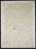
 3227CD King William's Town, South Africa 1:50000 sheet. Air photography 1964. Surveyed in 1971 and drawn in 1972 by the Trigonometrical Survey Office.
 -
 3226AC Alicedale South Africa 1:50000 sheet. Air photography 1957. Field survey 1962. Drawn by the Trigonometric Survey in 1963. T.S.O. 200/1893. (Lugfotografie 1957. Veldopmeting 1962. Saamgestel en geteken in 1963 deur die Driehokesmatings Kantoor.) First edition
 -
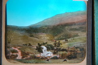
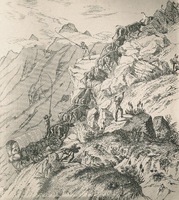 An iconic engraving by Charles Michell of an ox-wagon ascending Cradock Pass, Outeniqua Mountains, Cape. 1840. Michell, a Surveyor and Road Builder used this image to illustrate the dangerous ascent. This image has captured the imagination of South Africans for many generations
 -
 A general plan of Cradock taken from the plans of surveyors Aling, Chiappini and Rorders by F.H. Hopley, 1851? Manuscript copy of original.
 -
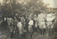 A photograph album compiled by Mary Butler, containing photographs of Wayfarers, Sunbeams and Pathfinders, mostly in Cradock. Two newspaper clippings and a handwritten concert programme included. There are three photographs of Rev. James Arthur Calata's young daughters, and he himself is included in two photographs. This photograph showing a group of young and older boys, Pathfinders, wearing uniform and performing a folk dance
 -
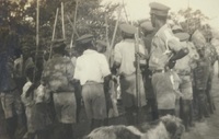 A photograph album compiled by Mary Butler, containing photographs of Wayfarers, Sunbeams and Pathfinders, mostly in Cradock. Two newspaper clippings and a handwritten concert programme included. There are three photographs of Rev. James Arthur Calata's young daughters, and he himself is included in two photographs. This photograph shows a group of young and older boys, Pathfinders, wearing uniform and performing a folk dance
 -
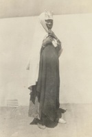 A photograph album compiled by Mary Butler, containing photographs of Wayfarers, Sunbeams and Pathfinders, mostly in Cradock. Two newspaper clippings and a handwritten concert programme included. There are three photographs of Rev. James Arthur Calata's young daughters, and he himself is included in two photographs. This photograph showing a woman wearing a veil, her face is smeared with clay
 -
 In P E Raper's "New Dictionary of South African Place Names", ISBN 1868421902, is this entry, on page 105: *Fort Willshire - Former fort at the confluence of the Keiskamma and Rhwantsana Rivers, 23km south-south-east of Alice, at 32 59S, 26 55E. It was named in honour of Lieutenant-Colonel Thomas Willshire, veteran of the Peninsular War, who took command in 1819.
 -
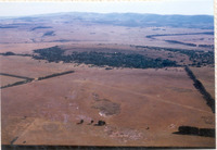 Aerial view of Bathurst suurveld, the old Zuure Veldt, looking north to Kap River Hills with the dome of Round Hill centrally.
 -
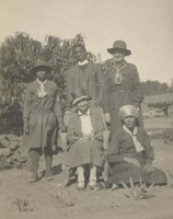 A photograph album compiled by Mary Butler, containing photographs of Wayfarers, Sunbeams and Pathfinders, mostly in Cradock. Two newspaper clippings and a handwritten concert programme included. There are three photographs of Rev. James Arthur Calata's young daughters, and he himself is included in two photographs. This photograph showing a Mrs E.C. (Alice Eyre) Butler with Wayfarer officers and Rev. James Arthur Calata
 -
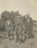 A photograph album compiled by Mary Butler, containing photographs of Wayfarers, Sunbeams and Pathfinders, mostly in Cradock. Two newspaper clippings and a handwritten concert programme included. There are three photographs of Rev. James Arthur Calata's young daughters, and he himself is included in two photographs. This photograph showing Mrs E.C. (Alice Eyre) Butler with Wayfarer officers and Rev. James Arthur Calata
 -
 A photograph album compiled by Mary Butler, containing photographs of Wayfarers, Sunbeams and Pathfinders, mostly in Cradock. Two newspaper clippings and a handwritten concert programme included. There are three photographs of Rev. James Arthur Calata's young daughters, and he himself is included in two photographs. This photograph showing a Mrs E.C. (Alice Eyre) Butler with Wayfarer officers and Rev. James Arthur Calata
 -
-
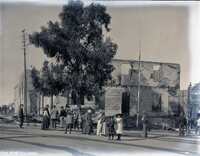
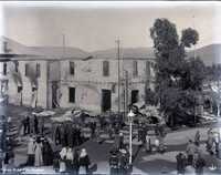 Glass negative : View of the aftermath of the Victoria Hotel fire, Cradock, July 1904.
 -
-
-
-
-
-
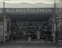 Glass negative : View of Allan & Coleman, General Dealers, Cradock, circa 1906, showing the front view of the shop.