Frontier Wars Collection
Item set
- Title
- Frontier Wars Collection
- Alternative Title
- The Frontier Wars
- Description
- The “The Frontier Wars” item set is a significant thematic collection within the Cory Library and Historical Archives’ digital holdings, documenting the series of conflicts along the Eastern Cape frontier between Indigenous Xhosa groups and colonial forces during the 18th and 19th centuries. These wars — often referred to as the Xhosa Wars in historical literature — were a defining feature of colonial expansion in southern Africa, significantly shaping the region's political, social, and geographic landscape. The collection brings together archival images, maps, and textual records that illuminate aspects of military engagements, frontier settlements, and the broader human experience of conflict on the Eastern Cape frontier.
- Date Issued
- Primarily 19th century (historical documentation dates)
- Language
- English
- Type
- Collection
- Subject
- South Africa--History--Frontier Wars, 1811-1878See all item sets with this value
- Eastern Cape -- History
- Colonial military history
- British--South Africa--History--19th centurySee all item sets with this value
- Xhosa People -- South Africa -- Eastern Cape -- History
- Format
- Digital images
- Digital manuscripts
- Spatial Coverage
- Eastern Cape, South Africa
- Cape Colony
- Temporal Coverage
- Late 18th–19th century frontier conflicts
Items
-
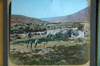 Two children and three men appear in the foreground, possibly including Sir George Cory.
 -
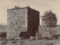
 Fort Armstrong (originally known as Camp Adelaide) was built in 1836 to protect the Kat River Settlement. After suffering capture and bombardment in the 8th Frontier war (1851), it was never used again.
 -
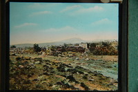 Fort Armstrong (originally known as Camp Adelaide) was built in 1836 to protect the Kat River Settlement. After suffering capture and bombardment in the 8th Frontier war (1851), it was never used again.
 -
-
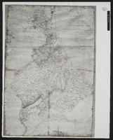
 Ordered by the House of Commons to be printed 12th July 1837.
 -
 Sketch of Fort Beaufort; approved by J. Hare and Chas. Bell A.S.G. ; no scale
 -
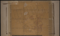 Signed by Charles Bell (Assistant Surveyor General.
 -
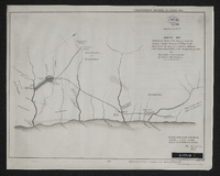
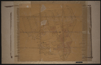
 Survey of a portion of the Kat River Settlement shewing the colonial boundary from Fort Beaufort to the Kat Berg, the military post at Fort Armstrong, Elands [Post], Mancasana and the abandoned posts at Echardts and Warden's. Photograph of original.
 -
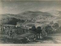 The capture of Fort Armstrong, 1851
 -
-
-
 Fort Brown, built by Andrew Geddes Bain in 1836 on a site previously known as Hermanus Kraal.
 -
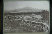
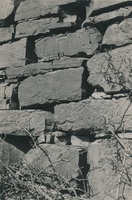
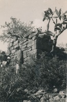 View of a corner of the ruins of Fort Willshire and detail of the stone work showing method of construction. Una Long : photographer
 -
 View of a corner of the ruins of Fort Willshire and detail of the stone work showing method of construction. Una Long : photographer
 -
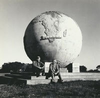
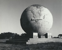 The Karel Landman Monument in the Sundays River Valley Rural, Eastern Cape, was designed by Gerard Moerdyk and built by the Lupini Brothers. It was unveiled on 16 December 1939 by W A L Landman. It honours Karel Landman who farmed in this area until 1837 when he became a leader in the Great Trek. He led a party of 180 Trekkers and their servants on a trek of 885 kilometres into Natal where he was prominent in several battles with the Zulus and he was second in command of the Boer forces at the pivotal battle of Blood River. The commemoration of Karel Landman and his trek, in this 3m globe with an ox wagon traversing it, was an initiative of the National Party and the councils of the Dutch Reformed Church in two neighbouring villages, Alexandria and Paterson. Legend has it that the councils could not agree which village should 'host’ the monument, so it was placed on this remote koppie overlooking the surrounding countryside, between the two villages.,F G Butler (donor)
 -
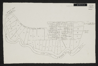 Woburn Military Village. No date on map but probably around 1848. Unsigned plan in some detail of the village, possibly as it was projected rather than as it actually appeared. Scale not stated. 1 sheet 14" x 9". Manuscript. From Sir George Cory's papers.