Frontier Wars Collection
Item set
- Title
- Frontier Wars Collection
- Alternative Title
- The Frontier Wars
- Description
- The “The Frontier Wars” item set is a significant thematic collection within the Cory Library and Historical Archives’ digital holdings, documenting the series of conflicts along the Eastern Cape frontier between Indigenous Xhosa groups and colonial forces during the 18th and 19th centuries. These wars — often referred to as the Xhosa Wars in historical literature — were a defining feature of colonial expansion in southern Africa, significantly shaping the region's political, social, and geographic landscape. The collection brings together archival images, maps, and textual records that illuminate aspects of military engagements, frontier settlements, and the broader human experience of conflict on the Eastern Cape frontier.
- Date Issued
- Primarily 19th century (historical documentation dates)
- Language
- English
- Type
- Collection
- Subject
- South Africa--History--Frontier Wars, 1811-1878See all item sets with this value
- Eastern Cape -- History
- Colonial military history
- British--South Africa--History--19th centurySee all item sets with this value
- Xhosa People -- South Africa -- Eastern Cape -- History
- Format
- Digital images
- Digital manuscripts
- Spatial Coverage
- Eastern Cape, South Africa
- Cape Colony
- Temporal Coverage
- Late 18th–19th century frontier conflicts
Items
-
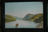
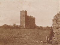 Photograph of an abandoned fort, possibly in the Eastern Cape, with a boy in the foreground
 -
-
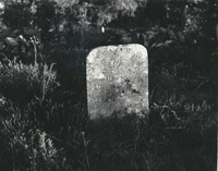
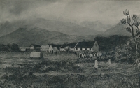
 Gravestone with the words “Hottentot victim of the [drawing of an axe] war 1846” engraved on it. Note on the back: “A Hottentot victim of the war of the axe 1846 45".
 -
 In P E Raper's "New Dictionary of South African Place Names", ISBN 1868421902, is this entry, on page 105: *Fort Willshire - Former fort at the confluence of the Keiskamma and Rhwantsana Rivers, 23km south-south-east of Alice, at 32 59S, 26 55E. It was named in honour of Lieutenant-Colonel Thomas Willshire, veteran of the Peninsular War, who took command in 1819.
 -
-
-
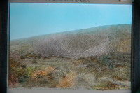 Fort Willshire was built by the Royal Engineers under Lieutenant Colonel Thomas Willshire of the 38th Regiment, on the orders of Lord Charles Somerset, in 1819.
 -
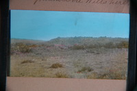 Fort Willshire was built by the Royal Engineers under Lieutenant Colonel Thomas Willshire of the 38th Regiment, on the orders of Lord Charles Somerset, in 1819.
 -
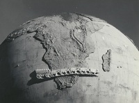 The Karel Landman Monument in the Sundays River Valley Rural, Eastern Cape, was designed by Gerard Moerdyk and built by the Lupini Brothers. It was unveiled on 16 December 1939 by W A L Landman. It honours Karel Landman who farmed in this area until 1837 when he became a leader in the Great Trek. He led a party of 180 Trekkers and their servants on a trek of 885 kilometres into Natal where he was prominent in several battles with the Zulus and he was second in command of the Boer forces at the pivotal battle of Blood River. The commemoration of Karel Landman and his trek, in this 3m globe with an ox wagon traversing it, was an initiative of the National Party and the councils of the Dutch Reformed Church in two neighbouring villages, Alexandria and Paterson. Legend has it that the councils could not agree which village should 'host’ the monument, so it was placed on this remote koppie overlooking the surrounding countryside, between the two villages.,F G Butler (donor)
 -
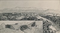 Drawing of Fort Hare by Mr G Porte.
 -
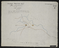
 Copied by Walter P. Jones, 21st July 1873. War Department number on map WD. X
 -
 Copied by Walter P. Jones, 23rd July 1873. War Department number on map WD. X
 -
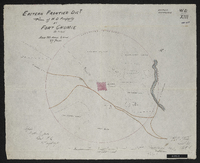
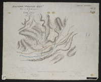
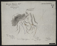
 Copied by Walter P. Jones, 17th July 1873. War Department number on map WD. VII
 -
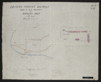
 Title 29th January 1944. Copied by Walter P. Jones, 21st August 1873. War Department number on map WD. XIII.
 -
 Copied by Walter P. Jones, 18th August 1873. War Department number on map WD. IV.
 -
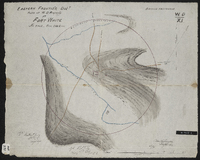 Copied by Walter P. Jones, 23rd July 1873. War Department number on map WD. XI.
 -
 Copied by Walter P. Jones, 19th August 1873. War Department number on map WD. VI.
 -
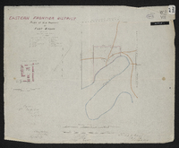
 Copied by Walter P. Jones, 23rd July 1873.War Department number on map WD. XIII.
 -
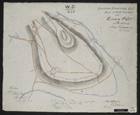
 Copied by Walter P. Jones, 18th August 1873. War Department number on map WD. XIV.
 -
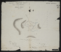 Copied by Walter P. Jones, 21st August 1873. War Department number on map WD. VII.
 -
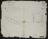 Copied by Walter P. Jones, 23rd July 1873. War Department number on map WD. XV.
 -
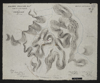 Copied by Walter P. Jones, 20th August 1873. War Department number on map WD. IX.
 -
 Copied by Walter P. Jones, 20th August 1873. provisionally handed over to the colonial government 5th April 1873, pending sanction from war office vide letter to v.s. of state for war of 12th March 1873, with H.E. the commander of the forces approval thereon on the same date. War Department number on map WD. X.
 -
 Copied by Walter P. Jones, 19th August 1873. War Department number on map WD. V.