Cory Map Collections
Item set
- Title
- Cory Map Collections
- Description
-
The Cory Map Collections form one of the most comprehensive cartographic repositories in Southern Africa. Curated by the Cory Library for Historical Research at Rhodes University, the collection is a vital resource for understanding the evolving spatial, political, and social boundaries of the Eastern Cape and the broader subcontinent.
The maps range from early 16th-century European depictions of the African continent to highly detailed 19th-century military surveys of the Eastern Cape frontier. They document the progress of colonial settlement, the demarcation of mission stations, the layout of frontier forts, and the development of early South African infrastructure like post offices and post-war schools. - Language
- English
- Afrikaans
- Temporal Coverage
- c. 1540 – 1980
- Cartographics - Scale
- Varies (from 1:5,000 for town plans to 1:1,000,000 for regional maps
- Format
- Vellum, linen-backed paper, and modern digital surrogates
Items
-
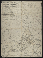
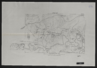 Spion Kop : area of operations Jan 17th to 26th 1900.
 -
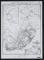 Photo-lithographed at the Government Printing Works, Pretoria.Revised 1 March 1916.
 -
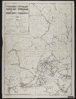 Photo-lithographed at the Government Printing Works, Pretoria, 1950. Compiled in the Office of the Chief Civil Engineer, S.A.R., Johannesburg
 -
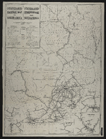 Drawn in the office of the Chief Civil Engineer, SAR, Johannesburg. Compiled on the basis of Bonne's projection (Central Meridian 25 East Longitude.
 -
 Drawn in the office of the Chief Civil Engineer, SAR, Johannesburg. Photo-lithographed at the Government Printing Works, Pretoria,[1925]. Two undated railway maps appended.
 -

-
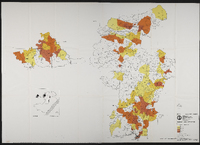 Maps to accompany "Statistical base for planning service centres in Transkei's north-west region" by Osmond Lange Vandeverre Haarhoff Goldswain and Burger, architects and regional planners. For the Department of Commerce, Industry and Tourism, Republic of Transkei. Map 1 north west region, Map 2 north east region.
 -
 Survey of a portion of the Kat River Settlement shewing the colonial boundary from Fort Beaufort to the Kat Berg, the military post at Fort Armstrong, Elands [Post], Mancasana and the abandoned posts at Echardts and Warden's. Photograph of original.
 -
 "Fine pasture country uninhabited and considered neutral ground".
 -
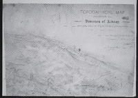 Topographical map of the division of Albany shewing the area covered by the 1st section of the triangulation. Surveyed for the Colonial [Office] by me Ernest ...
 -
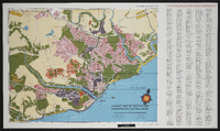 Tourist map of East London showing places of interest. Produced by the East London Publicity Association in conjunction with Shell South Africa (Pty) Limited. Compiled and drawn by B. L. Walton, October 1955.
 -
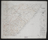 This map forms part of the Imperial map of the Cape Colony.,"South Africa having never been properly surveyed, this map must necessarily contain many inaccuracies." The map shows main roads, branch roads, farm roads, rivers, hills, pans, railways, telegraph lines, farm names, farm boundaries, divisional boundaries, outspans and homesteads in the Transkei region.Compiled and lithographed by Mapping Section, F.I.D., Cape Town, under the superintendence of P.H. du P. Casgrain from farm surveys and all other available information.
 -
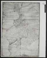
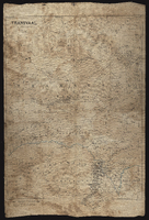 Transvaal, compiled and lithographed at the Intelligence Dept., Horse Guards, January 1881.
 -
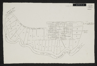 Woburn Military Village. No date on map but probably around 1848. Unsigned plan in some detail of the village, possibly as it was projected rather than as it actually appeared. Scale not stated. 1 sheet 14" x 9". Manuscript. From Sir George Cory's papers.