Cory Map Collections
Item set
- Title
- Cory Map Collections
- Description
-
The Cory Map Collections form one of the most comprehensive cartographic repositories in Southern Africa. Curated by the Cory Library for Historical Research at Rhodes University, the collection is a vital resource for understanding the evolving spatial, political, and social boundaries of the Eastern Cape and the broader subcontinent.
The maps range from early 16th-century European depictions of the African continent to highly detailed 19th-century military surveys of the Eastern Cape frontier. They document the progress of colonial settlement, the demarcation of mission stations, the layout of frontier forts, and the development of early South African infrastructure like post offices and post-war schools. - Language
- English
- Afrikaans
- Temporal Coverage
- c. 1540 – 1980
- Cartographics - Scale
- Varies (from 1:5,000 for town plans to 1:1,000,000 for regional maps
- Format
- Vellum, linen-backed paper, and modern digital surrogates
Items
-
 Outline maps of the territory between the Kei and Bashee Rivers. Some mission stations marked. 2 scales given on MP 1456 (1" = c.5 miles and 1½" = c.5 miles); no scale given on MP 1457.
 -
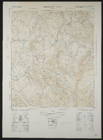 Palingkloof 3226AA. South Africa 1:50000 sheet. Air photography 1943. Field survey 1945. Drawn by the Trigonometric Survey in 1953. T.S.O. 200/1048. (Lugfotografie 1943. Veldopmeting 1945. Saamgestel en geteken in 1953 deur die Driehokesmatings Kantoor.) First edition
 -
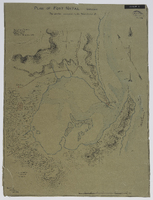
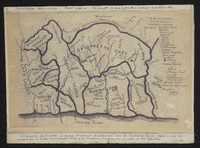
 Respectfully presented to the Colonial Government with a memoir signed by R. Moffat Jun. .. Kuruman, Jan., 1857.
 -
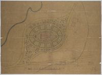
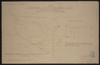
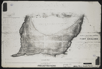 Plan of a section of ground situated between Fort England and the property of Mr John Carlisle, shewing its subdivision into allotments form actual survey executed by order of Government in the months of January and February 1857…
 -
 Surveyed by Lt. Williams ; drawn by H.W. Piers, Jan. 1839.
 -
 "Plan probably drawn 1824. Copied by E. Lewcock, Sept. 1962. Original in Albany Museum, Courtesy Surveyor-General."
 -
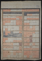
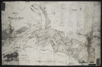 Plan of Grahamstown noting owners of erven 1 to 20 and at Cape Corps Barracks (Fort England). Duplicate of MP145. The map is unsigned and a photocopy. Given to the Cory Library by Mr. K.S. Hunt
 -
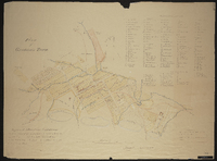
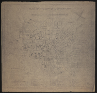
 Map 1 in the map album accompanying the thesis by Hilstan Lett Watts, "Grahamstown : a socio-ecological study of a small South African town", Rhodes University thesis, 1957. Map signed 1955. This map is based on a municipal map, with necessary corrections. Street widths are exaggerated for the purpose of clarity. The street pattern shown is for the town in 1951. The so-called "Hottentot Village" is today the Coloured location.
 -
 Letterbook copy of a plan of Lovedale, annotated 1846, changed to 1856.
 -
 Plan of Port Elizabeth (Cape Colony). Supplement to Donaldson and Hill's Eastern Province Cape Colony directory, 1904.
 -
 Divided and planned by Joh. H. Fort (1864) with later transfer subdivisions by W.R. Piers (1880).
 -
-
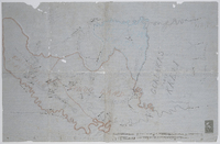
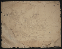
 Plan of Territories formerly known as Kaffraria proper: simplified handdrawn copy of the 1884 map of the territories formerly known as Kaffraria, with additional information inserted by Alfred William Burton. Surveyors C.P. Watermeyer; Fletcher ; MacDonald, Schunke, Tilney, Norris, Greeff, Greathead, F. Watermeyer; Erskine, Hughes R.N., Changuion, Pritchard and O. Mehliss, and military sketches by Messrs Colley and Grant and the Intelligence Branch of the Quartermaster General's Department. Photocopy stuck on card. Transkeian territories. First produced in 1884 by 14 surveyors and 3 others.See MP 307, L (77) d 1 for the original map by fourteen surveyors and Military sketches.
 -
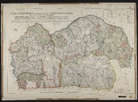 Plan of Territories formerly known as Kaffraria proper, lying between the following boundaries, The Quathlamba range on the north, the sea coast on the east, Natal on the north east and the Kei and Indwe on south west. Compiled by plans of surveys by surveyors C.P. Watermeyer; Fletcher; MacDonald, Schunke, Tilney, Norris, Greeff, Greathead, F. Watermeyer; Erskine, Hughes R.N., Changuion, Prithcard and O. Mehliss, and military sketches by Messrs Colley & Grant & the Intelligence Branch of the Quartermaster General's Department. Includes approximate table of distances from Kokstad to several magistracies and Umtata. Map signed by A (Abraham) de Smidt, surveyor general.
 -
-
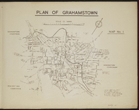
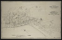
 Plan of the City of Grahamstown, 1934 prepared by A W Marshall, City Engineer's Department.
 -
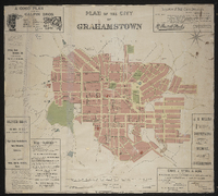 Plan of the city of Grahamstown; framed from survey and compilation in 1887 by E.D. Barker, GLS and R.S. Fairbridge GLS … by Ernest Grubb, City Engineer. "London Geographical Institute".
 -
 Plan of the City of Grahamstown, 1924 compiled in the Office of the Surveyor General, Cape Town. Compiled from plans and diagrams filed in the office of the Registrar of Deeds and Surveyor General Cape Town.
 -

-
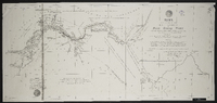
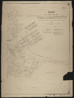
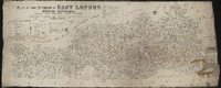 Plan of the division of East London, British Kaffraria, taken from general plans framed by D. Macdonald, A. E. Murray, E.T. Cooper, H.E.R. Bright, J.X. Merriman, J. Powell, E. Griffiths, W.D. Dumbleton, C. Watermeyer, H. Bryant, Lieutenant Colley, C.A. Smith and C.J. Gray, Government Surveyors; Compiled by C. Neumann Thomas, Surveyor General's Office, Cape Town, 1867. Scale 1" = 4000 Cape Roods. 1 sheet 30" x 72". Showing Field Cornetcy areas and Leased Lots.
 -
-
 Drawn by A.W.M. ; signed by W.A. Hodge, City Engineer.
 -
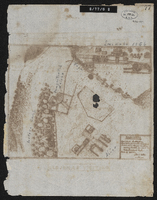
 Plan shewing military defences of King Williams Town; [by] Geo. Newey.
 -
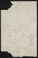
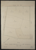 Plan showing proposed subdivisions of Erf 2918, Grahamstown, September 1977.
 -
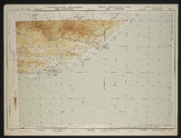 Port Elizabeth (3421). Aeronautical chart of Port Elizabeth region, South Africa. Compiled and drawn by the Trigonometrical Survey Office, 1953. Reprinted by the Government Printer in 1956. Hypsometric tints for Africa south of 16° south latitude. Elevations in feet. T.S.O. 607/836. Topographic base, 1952. First edition.