Cory Map Collections
Item set
- Title
- Cory Map Collections
- Description
-
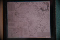
The Cory Map Collections form one of the most comprehensive cartographic repositories in Southern Africa. Curated by the Cory Library for Historical Research at Rhodes University, the collection is a vital resource for understanding the evolving spatial, political, and social boundaries of the Eastern Cape and the broader subcontinent.
The maps range from early 16th-century European depictions of the African continent to highly detailed 19th-century military surveys of the Eastern Cape frontier. They document the progress of colonial settlement, the demarcation of mission stations, the layout of frontier forts, and the development of early South African infrastructure like post offices and post-war schools. - Language
- English
- Afrikaans
- Temporal Coverage
- c. 1540 – 1980
- Cartographics - Scale
- Varies (from 1:5,000 for town plans to 1:1,000,000 for regional maps
- Format
- Vellum, linen-backed paper, and modern digital surrogates
Items
-
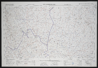
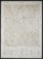 3227 DB Komga, South Africa 1:50000 sheet, first edition. Air photography 1953, surveyed in 1960, drawn in 1962 by the Trigonometric Survey Office. T.S.O. 200/1620. (Lugfotografie 1953, opgemeet in 1960, en geteken in 1962 deur die Driehokesmatings Kantoor.),1st edition
 -
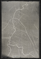
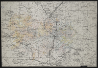 Photograph of a map of the area around Ladysmith, mainly south of the town.Probably a copy of part of a general topographical series.
 -
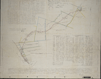 Diagram of the land between the Langholme estates and Martindale station … which is to be used by the African Canning and Packing Corporation Ltd for railway purposes … [by] Rex Sucker… Grahamstown, D.G. Iverach, 25.3.1923 ; approved by the Surveyor General.
 -
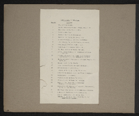 List of maps in the map album accompanying the thesis by Hilstan Lett Watts, "Grahamstown : a socio-ecological study of a small South African town", Rhodes University thesis, 1957.
 -
 3018 Loeriesfontein, South Africa 1:25000 sheet. Compiled and drawn in 1961 by the Trigonometric Survey Office. Magisterial districts as at May 1961. T.S.O. 404/953. (Saamgestel en geteken in 1960 deur die Driehokesmatings Kantoor.)
 -
 Plan of land around Lovedale; some of it marked for "alienation" - owners of some property shown. (Negative) Photograph of origincal manuscript, 1875.
 -
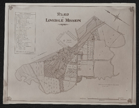 Plan of Lovedale Mission 1902. Photograph.
 -
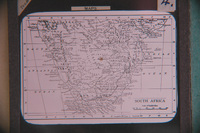
 [Imperial map of South Africa] : Maclear compiled and lithographed by Mapping Section F.I.D. Cape Town under the superintendance of Capt. P.H. Du P. Casgrain ... from farm surveys and all other available information, [Wood and Ortlepp] [1900].
 -
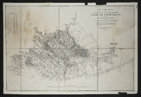
 Attached to Report of the commissioners appointed to inquire into the question of the northern boundary of Griqualand West : with minutes of evidence, minutes of proceedings, map and plans, Cape of Good Hope Ministerial Department of Crown Lands and Public Works.
 -
-
-
-
-
-
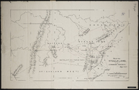 Map of Stellaland showing the surrounding territories signed by R.A. Lavertine,[1884]
 -
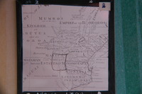
 Lithographed by James Wyld, geographer to the Queen 457 Strand, 11 & 12 Charing Cross S.W. and 2 Royal Exchange E.C.,1849. Note: the position of the military posts are marked by a red circle, and the present colonial boundary is marked with a red tint. Copy of the original.
 -
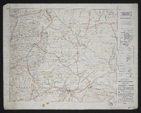
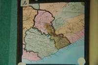
 Map of the district of Matatiele; compiled from maps, plans and diagrams filed in the Surveyor General's Office, Cape Town [by] C. Neumann Thomas.
 -
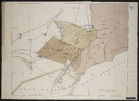
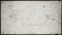
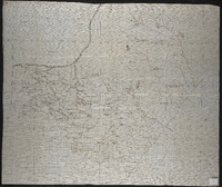
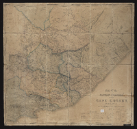 Map of the Eastern frontier of the Cape Colony, compiled by Henry Hall, a draughtsman to the Royal engineers, Cape Town, from military and other surveys, and dedicated by permission to J.F. Burgoyne. Published London, Edward Stanford.
 -
 Map of the Great Fish River Irrigation Board. C.H. Hughes, circle engineer; A.D. Lewis, Director of Irrigation.
 -
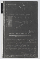 Diagram of a subdivision of the extension to Capt Thomas Butler's location, now known as portion 3 of the farm Melville Park, situated in the division of Albany, subdivided 9th November 1843 [by] Thomas Okes. Photograph negative.
 -
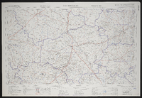 3124 Middelburg, South Africa 1:25000 sheet. Compiled and drawn in 1960 by the Trigonometric Survey Office. Magisterial districts as at May 1960. T.S.O. 404/963. (Saamgestel en geteken in 1960 deur die Driehokesmatings Kantoor.)
 -
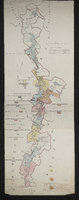
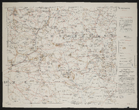
 Missionary map of the Queenstown district showing Methodist, Anglican, Moravian, United Presbyterian and Free Church of Scotland stations.
 -
 [Imperial map of South Africa] : Murraysburg compiled and lithographed by Mapping Section F.I.D. Cape Town under the superintendance of Capt. P.H. Du P. Casgrain ... from farm surveys and all other available information, [Wood and Ortlepp] [1900].
 -
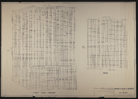
 Copied from plan no. 1826, J.C.H.G. draftsman. With lists of grantees of lots.
 -
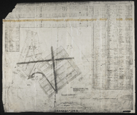
 Municipality of the city of Grahamstown. Parks. Old cemetery. Feb 1987. Showing Wesleyan, Anglican, Baptis, Presbyterian, Roman Catholic.