Cory Map Collections
Item set
- Title
- Cory Map Collections
- Description
-
The Cory Map Collections form one of the most comprehensive cartographic repositories in Southern Africa. Curated by the Cory Library for Historical Research at Rhodes University, the collection is a vital resource for understanding the evolving spatial, political, and social boundaries of the Eastern Cape and the broader subcontinent.
The maps range from early 16th-century European depictions of the African continent to highly detailed 19th-century military surveys of the Eastern Cape frontier. They document the progress of colonial settlement, the demarcation of mission stations, the layout of frontier forts, and the development of early South African infrastructure like post offices and post-war schools. - Language
- English
- Afrikaans
- Temporal Coverage
- c. 1540 – 1980
- Cartographics - Scale
- Varies (from 1:5,000 for town plans to 1:1,000,000 for regional maps
- Format
- Vellum, linen-backed paper, and modern digital surrogates
Items
-
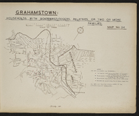
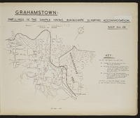 Map 25 in the map album accompanying the thesis by Hilstan Lett Watts, "Grahamstown : a socio-ecological study of a small South African town", Rhodes University thesis, 1957. Map signed 1955. The data are from the sample survey of the European area of Grahamstown.
 -
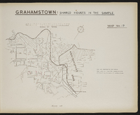
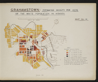 Map 14 in the map album accompanying the thesis by Hilstan Lett Watts, "Grahamstown : a socio-ecological study of a small South African town", Rhodes University thesis, 1957. Map signed 1955. The data are based on number of persons per street, estimated on the basis of the survey sample, and the total acreage covered by housing plots in the street (excluding unoccupied plots) obtained from the municipal valuation roll for Grahamstown, 1953.
 -
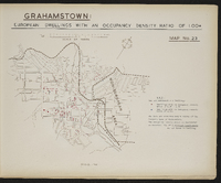 Map 23 in the map album accompanying the thesis by Hilstan Lett Watts, "Grahamstown : a socio-ecological study of a small South African town", Rhodes University thesis, 1957. Map signed 1955. The data are from the sample survey of the European area of Grahamstown
 -
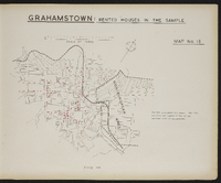
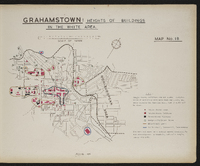 Map 18 in the map album accompanying the thesis by Hilstan Lett Watts, "Grahamstown : a socio-ecological study of a small South African town", Rhodes University thesis, 1957. Map signed 1955. Data are based on a special survey conducted by the investigator. A complete and not a sample survey was made.
 -
 Map 24 in the map album accompanying the thesis by Hilstan Lett Watts, "Grahamstown : a socio-ecological study of a small South African town", Rhodes University thesis, 1957. Map signed 1955. The data are from the sample survey of the European area of Grahamstown.
 -
 Map 6 in the map album accompanying the thesis by Hilstan Lett Watts, "Grahamstown : a socio-ecological study of a small South African town", Rhodes University thesis, 1957. Map signed 1955.
 -
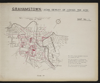 Map 11 in the map album accompanying the thesis by Hilstan Lett Watts, "Grahamstown : a socio-ecological study of a small South African town", Rhodes University thesis, 1957. This map is based on the municipal valuation roll for Grahamstown, 1953. Map signed 1955.
 -
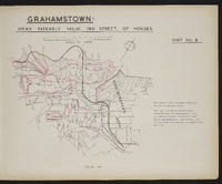 Map 8 in the map album accompanying the thesis by Hilstan Lett Watts, "Grahamstown : a socio-ecological study of a small South African town", Rhodes University thesis, 1957. Map signed 1955. This map is based on the Municipal Valuation Roll for Grahamstown, 1953. The rateable values are based on mean values calculated for each street. The map represents parameters as sampling was not used.
 -
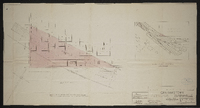 Grahamstown : Plan showing portion of Cemetery required by S.A.R. ; plan aantonende gedeelte van begraafplek deur S.A.S. Signed by District Engineer, 26.4.54 ; System engineer 30.4.54 ; System manager 3.5.54 ; scale as shown 26.4.54 ; No PE 138, A 9.
 -
 Map 15 in the map album accompanying the thesis by Hilstan Lett Watts, "Grahamstown : a socio-ecological study of a small South African town", Rhodes University thesis, 1957. Map signed 1955. The data are from the sample survey of the European area of Grahamstown.
 -
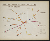 Diagram 6 in the map album accompanying the thesis by Hilstan Lett Watts, "Grahamstown : a socio-ecological study of a small South African town", Rhodes University thesis, 1957. Map signed 1955. This diagram is based on a S.A.R. diagram and is not to scale. Bus service frequencies are for scheduled regular services only and are taken from the 1953 S.A.R. timetable (no. 150, 15th June 1953).
 -
 Map 17 in the map album accompanying the thesis by Hilstan Lett Watts, "Grahamstown : a socio-ecological study of a small South African town", Rhodes University thesis, 1957. Map signed 1955. Data are from a sample survey of the European area of Grahamstown.
 -
 Map 9 in the map album accompanying the thesis by Hilstan Lett Watts, "Grahamstown : a socio-ecological study of a small South African town", Rhodes University thesis, 1957. Map signed 1955. Data obtained from the Department of Social Welfare's Office in Grahamstown, and school records of the Cape Provincial Education Department ; also from the Magistrate's Court records.
 -
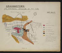 Map 27 in the map album accompanying the thesis by Hilstan Lett Watts, "Grahamstown : a socio-ecological study of a small South African town", Rhodes University thesis, 1957. Map signed 1955.
 -
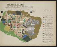
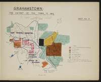 Map 3 in the map album accompanying the thesis by Hilstan Lett Watts, "Grahamstown : a socio-ecological study of a small South African town", Rhodes University thesis, 1957. Map signed 1955. Based on an original map in the Cory Library, Rhodes University.
 -
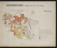 Map 20 in the map album accompanying the thesis by Hilstan Lett Watts, "Grahamstown : a socio-ecological study of a small South African town", Rhodes University thesis, 1957. Map signed 1955. The data are from the sample survey of the European area of Grahamstown.
 -
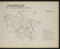
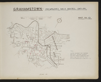 Map 10 in the map album accompanying the thesis by Hilstan Lett Watts, "Grahamstown : a socio-ecological study of a small South African town", Rhodes University thesis, 1957. Map signed 1955. The map represents the total number of unemployed male whites registered with the Labour Office in Grahamstown during 1947-1951.
 -
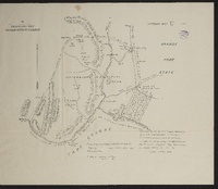
 Grahamstown and surrounding farms compiled from diagrams annexed to their respective grants in the Surveyor-General's Office; by D. Kryndow. Copy of original manuscript.
 -
 Griqualand West Northern Boundary Commission, Appendix map C, Filed among the Griqua government records, Colesberg, 1863. Surveyor General Office 1881. Filed by David Arnot, Griqua Secretary, agent and representative of the chief Waterboer and government at Colesberg in letter to his excellency Sir P.E. Wodehouse, her Britannic Majesty's high commissioner for South Africa.
 -
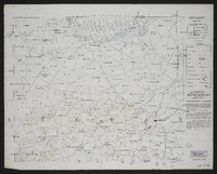
 Inspection of telegraph line - G. McKay, East London to Potsdam - C. Brownlee, King Williams Town to Potsdam; [comp. by G. McKay?].Scale not stated. 1 sheet 14½" x 22". Manuscript; may be dated "1868".
 -
 3228 Kei Mouth, South Africa 1:25000 sheet. Compiled and drawn in 1960 by the Trigonometric Survey Office. Magesterial districts as at August 1960. T.S.O. 404/971. (Saamgestel in 1960 en geteken in 1960 deur die Driehokesmatings Kantoor.)
 -
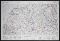
 3327 DA Kei Road, South Africa 1:50000 sheet, first edition. Air photography 1953, surveyed in 1960, drawn in 1962 by the Trigonometric Survey Office. T.S.O. 200/1635. (Lugfotografie 1953, opgemeet in 1960, en geteken in 1962 deur die Driehokesmatings Kantoor.),1st edition
 -
-
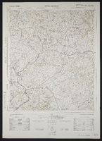
 [Imperial map of South Africa] : Kingwilliamstown compiled by the [British Military] Intelligence Department, 1900?
 -
 3028 Kokstad, South Africa 1:25000 sheet. Compiled and drawn in 1959 by the Trigonometric Survey Office. Magisterial districts as at July 1964. T.S.O. 404/958. (Saamgestel en geteken in 1960 deur die Driehokesmatings Kantoor.)