Cory Map Collections
Item set
- Title
- Cory Map Collections
- Description
-
The Cory Map Collections form one of the most comprehensive cartographic repositories in Southern Africa. Curated by the Cory Library for Historical Research at Rhodes University, the collection is a vital resource for understanding the evolving spatial, political, and social boundaries of the Eastern Cape and the broader subcontinent.
The maps range from early 16th-century European depictions of the African continent to highly detailed 19th-century military surveys of the Eastern Cape frontier. They document the progress of colonial settlement, the demarcation of mission stations, the layout of frontier forts, and the development of early South African infrastructure like post offices and post-war schools. - Language
- English
- Afrikaans
- Temporal Coverage
- c. 1540 – 1980
- Cartographics - Scale
- Varies (from 1:5,000 for town plans to 1:1,000,000 for regional maps
- Format
- Vellum, linen-backed paper, and modern digital surrogates
Items
-
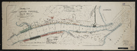
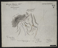 Copied by Walter P. Jones, 19th August 1873. War Department number on map WD. V.
 -
-
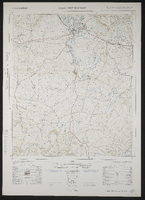
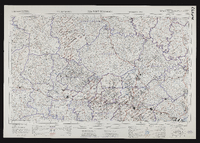 3226 Fort Beaufort, South Africa 1:25000 topo-cadastral sheet, Suid Afrika 1 : 25000 topo-kadastrale vel, cadastral information supplied by the Surveyors General Office. TSO 404/970. Compiled and drawn in 1960 by the Trigonometrical Survey Office.
 -
 3226 Fort Beaufort, South Africa 1:25000 sheet. Compiled and drawn in 1960 by the Trigonometric Survey Office. Magisterial districts as at March 1965. T.S.O. 404/970. (Saamgestel en geteken in 1960 deur die Driehokesmatings Kantoor.)
 -
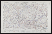
 3226 Fort Beaufort, South Africa 1:50000 topo-cadastral sheet, Suid Afrika 1 : 50000 topo-kadastrale vel, Kadastrale informasie verskaf deur die Landmeter-Generaal, Kaap. TSO 200/1737. Air photography 1949. Surveyed in 1961 and drawn in 1962 by the Trigonometrical Survey Office. Lugfotografie 1949. Opgemeet 1961 en geteken in 1962 deur die Driehoeksmeting Kantoor. First edition.
 -

-
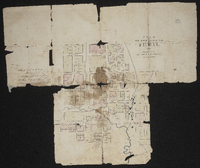 Free Church mission and Fort Hare : plan of the location and buildings. Not a clear document.
 -
 Free Church mission and Fort Hare : plan of the location and buildings. Not a clear document.
 -
 Farms: Carel's Rust, Springvale or Zuur Kloof, Procter's Fontein, Assegaai Bush, J.D.P. Francis' Farm, Komga. Granted 1833-1835.
 -
-
-
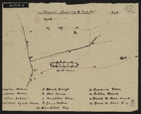
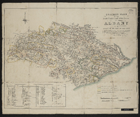
 General plan of the triangulation of the southern part of the Cape Colony 1859.1862. W. Bailey, Captain Royal Engineers, Superintendant Trigonometrical Survey, 21 January 1863. A rough diagram has been constructed for the purpose of shewing the relative positions of the beacons erected and permanent objects observed in the course of the Triangulation and its connection with the stations of Sir T MacLear in the measurement of an arc of meridian. The diagram is tolerably accurate.
 -
 3224 Graaff-Reinet , South Africa 1:25000 sheet. Compiled and drawn in 1960 by the Trigonometric Survey Office. Magisterial districts as at July 1964. T.S.O. 404/969. (Saamgestel en geteken in 1960 deur die Driehokesmatings Kantoor.)
 -
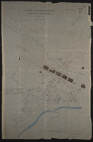
 Street map of Grahamstown. This map was compiled and executed by Roy Haupt. [1965]. Printed by Cape and Transvaal Printers Ltd.
 -
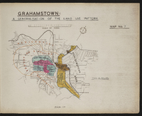 Map 7 in the map album accompanying the thesis by Hilstan Lett Watts, "Grahamstown : a socio-ecological study of a small South African town", Rhodes University thesis, 1957. Map signed 1955.
 -
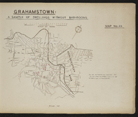
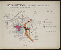 Map 12 in the map album accompanying the thesis by Hilstan Lett Watts, "Grahamstown : a socio-ecological study of a small South African town", Rhodes University thesis, 1957. Map signed 1955. The data are from the sample survey of the European area of Grahamstown.
 -
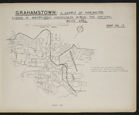
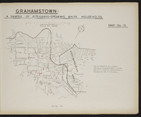 Map 19 in the map album accompanying the thesis by Hilstan Lett Watts, "Grahamstown : a socio-ecological study of a small South African town", Rhodes University thesis, 1957. Map signed 1955. The data are from the sample survey of the European area of Grahamstown.
 -
 Map 26 in the map album accompanying the thesis by Hilstan Lett Watts, "Grahamstown : a socio-ecological study of a small South African town", Rhodes University thesis, 1957. Map signed 1955. The data are from the sample survey of the European area of Grahamstown.
 -
 Map 13 in the map album accompanying the thesis by Hilstan Lett Watts, "Grahamstown : a socio-ecological study of a small South African town", Rhodes University thesis, 1957. Map signed 1955. The data are from the sample survey of the European (white) area of Grahamstown.
 -
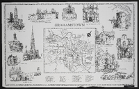
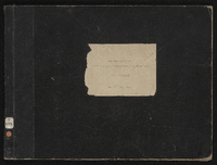 Cover of the map album accompanying the thesis by Hilstan Lett Watts, "Grahamstown : a socio-ecological study of a small South African town", Rhodes University thesis, 1957.
 -
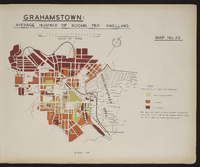 Map 22 in the map album accompanying the thesis by Hilstan Lett Watts, "Grahamstown : a socio-ecological study of a small South African town", Rhodes University thesis, 1957. Map signed 1955. The data are based on mean values calculated for each street, using survey sample data for the number of rooms per dwelling.
 -
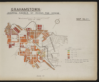 Map 21 in the map album accompanying the thesis by Hilstan Lett Watts, "Grahamstown : a socio-ecological study of a small South African town", Rhodes University thesis, 1957. Map signed 1955. The data are based on mean values calculated for each street, using survey sample data for the number of rooms per house.
 -
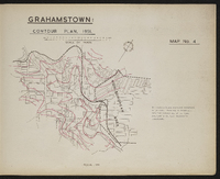 Map 4 in the map album accompanying the thesis by Hilstan Lett Watts, "Grahamstown : a socio-ecological study of a small South African town", Rhodes University thesis, 1957. Map signed 1955. This map is based on a detailed contour map of the town, prepared by the City Enginner's Department.
 -
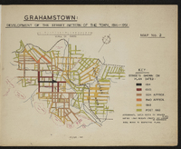 Map 2 in the map album accompanying the thesis by Hilstan Lett Watts, "Grahamstown : a socio-ecological study of a small South African town" ; Rhodes University thesis, 1957. Map signed 1955.
 -
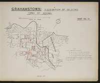 Map 16 in the map album accompanying the thesis by Hilstan Lett Watts, "Grahamstown : a socio-ecological study of a small South African town", Rhodes University thesis, 1957. Map signed 1955. Data are based on a special survey conducted by the investigator. A complete and not a sample survey was made.