Cory Map Collections
Item set
- Title
- Cory Map Collections
- Description
-
The Cory Map Collections form one of the most comprehensive cartographic repositories in Southern Africa. Curated by the Cory Library for Historical Research at Rhodes University, the collection is a vital resource for understanding the evolving spatial, political, and social boundaries of the Eastern Cape and the broader subcontinent.
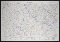
The maps range from early 16th-century European depictions of the African continent to highly detailed 19th-century military surveys of the Eastern Cape frontier. They document the progress of colonial settlement, the demarcation of mission stations, the layout of frontier forts, and the development of early South African infrastructure like post offices and post-war schools. - Language
- English
- Afrikaans
- Temporal Coverage
- c. 1540 – 1980
- Cartographics - Scale
- Varies (from 1:5,000 for town plans to 1:1,000,000 for regional maps
- Format
- Vellum, linen-backed paper, and modern digital surrogates
Items
-
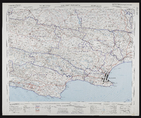
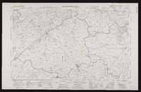
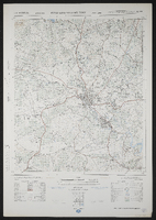 3227CD King William's Town, South Africa 1:50000 sheet. Air photography 1964. Surveyed in 1971 and drawn in 1972 by the Trigonometrical Survey Office.
 -
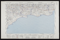
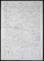 3227DC Berlin, South Africa 1:50000 sheet. Air photography 1964. Surveyed in 1971 and drawn in 1973 by the Trigonometrical Survey Office. Lugfotografie 1964. Opgemeet in 1971 en geteken in 1973 deur die Driehoeksmeting Kantoor. T.S.O. 200/5495. Kadastrale inligting verskaf deur die Landmeter, Kaap. Second edition,Second edition
 -
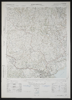 3227DD Cambridge, South Africa 1:50000 sheet. Air photography 1938, 1954 and 1959. Surveyed and drawn in 1963 by the Trigonometrical Survey Office. Lugfotografie 1938, 1954 and 1959. Opgemeet en geteken in 1963 deur die Driehoeksmeting Kantoor. T.S.O. 200/2000. Cadastral information supplied by the Surveyor-General, Cape. Second edition,Second edition
 -
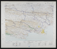 3324 Port Elizabeth, South Africa 1:25000 sheet. Opgemeet in 1971 en geteken in 1972 deur die Direkteur-Generaal van Opmetings Kadastraal hersien 1974. Surveyed in 1971 and drawn in 1972 by the Director General of Surveys Cadastral revised 1974. T.S.O. 404/6646. Magisterial districts as at June 1975. Second edition.,Second
 -
 3324 Port Elizabeth, South Africa 1:25000 sheet. Compiled and drawn in 1960 by the Trigonometric Survey Office. Magisterial districts as at January 1964. T.S.O. 404/976. (Saamgestel en geteken in 1960 deur die Driehokesmatings Kantoor.)
 -
 3226AC Alicedale South Africa 1:50000 sheet. Air photography 1957. Field survey 1962. Drawn by the Trigonometric Survey in 1963. T.S.O. 200/1893. (Lugfotografie 1957. Veldopmeting 1962. Saamgestel en geteken in 1963 deur die Driehokesmatings Kantoor.) First edition
 -
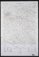 3226BC Grahamstown South Africa 1:50000 sheet. Air photography 1949. Field survey 1958. Drawn by the Trigonometric Survey in 1964. T.S.O. 200/1464. (Lugfotografie 1949. Veldopmeting 1958. Saamgestel en geteken in 1964 deur die Driehokesmatings Kantoor.) First edition
 -
 3420 Riversdale, South Africa 1:25000 sheet. Compiled and drawn in 1960 by the Trigonometric Survey Office. Magisterial districts as at November 1960. T.S.O. 404/978. (Saamgestel en geteken in 1960 deur die Driehokesmatings Kantoor.)
 -
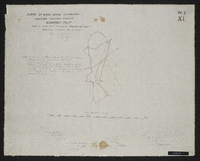
 A general plan of Cradock taken from the plans of surveyors Aling, Chiappini and Rorders by F.H. Hopley, 1851? Manuscript copy of original.
 -
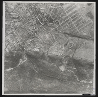 Photograph of Grahamstown from the air. Pretoria, Trigonometrical Survey Office, 1949.
 -
 Diagrams and/or survayor's descriptions of the farms: Springvale, Proctor's Fontein, Komga, Boekenhoud Fontein (Petrus de Wit J. Wilmot), Assegaai Bush (Johannes Potgieter), Klip Fontein, Carel's Rust (Nics. Niemand), Latham's Farm (Joseph Latham), Matjes Kraal, Seven Fountains, Faber's Kraal (Fred. Potgieter), Hartebeest Pad (Diedk. Niemand), Melville Park (Thos. Butler, George Slater), Sharon (T.C. White), farm of J.D.P. Francis. Negative copy of original, 1874. Signed A. de Smidt.
 -
 3222 Beaufort West, South Africa 1:25000 sheet. Compiled and drawn in 1959 by the Trigonometric Survey Office. Magisterial districts as at November 1960. T.S.O. 404/968. (Saamgestel in 1960 en geteken in 1960 deur die Driehokesmatings Kantoor.)
 -
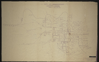
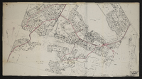 Master layout plan, showing layout of streets and the locations of schools, playing fields, shops, nursery schools, cinemas, clinics, nursing homes, garages, hotels, churches, government buildings, community centres, parks, nursing homes and the railway station. The map also shows the areas around Bethelsdorp including Chatty, Varsvlei, Missionvale, Gelanse, the S.A.N.T.A. hospital and surrounding area, sites for a university, a training college and a technical college as well as a saltpan and salt works. Designed by W.A. Smith. B-Y-9.
 -
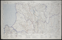
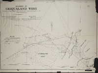 Boundary of Griqualand West (MP416d)compiled by the Surveyor General's records from the surveys in progress by Mr. Surveyor J.H. Ford and from personal observation. Boundary beaconed by Mr.Surveyor Ford, recommended by Colonel Mosey, and approved MM Aby. Lithographed and printed by W.A. Richards and Son, Cape Town. Plan attached to the Griqualand West Northern Boundary Commission (MP416e), dated June 21, 1883 ; Boundary recommended the lines ST and TU, S. Melvill, 4th July 1883.
 -
 3022 Britstown, South Africa 1:25000 sheet. Compiled and drawn in 1961 by the Trigonometric Survey Office. Magisterial districts as at June 1961. T.S.O. 404/955. (Saamgestel in 1960 en geteken in 1961 deur die Driehokesmatings Kantoor.)
 -
 Diagram of the location … and extension thereof ceded to Capt. Thomas Butler's party, now the farm Melville Park, in the district of Albany; surveyed 13th June 1826 [by] Wm. J. Brown. Photo negative.
 -
 3118 Calvinia, South Africa 1:25000 sheet. Compiled and drawn in 1960 by the Trigonometric Survey Office. Magisterial districts as at February 1961. T.S.O. 404/960. (Saamgestel in 1960 en geteken in 1960 deur die Driehokesmatings Kantoor.)
 -
 Cape of Good Hope; by J[ohn] Arrowsmith, [1842], possibly pusblished by J. Arrowsmith, this map is with permission copied from the original ms drawing in the Colonial Office compiled by Mr Herbert senr.
 -
 "Fine pasture country uninhabited and considered neutral ground". Title 29th January 1944. Copied by Walter P. Jones, 21st July 1873.
 -
 Diagram of Carel's Rust in the division of Albany, field-cornetcy of Assegaai Bush, granted to Nicolaas Niemand; surveyed by Wm. J. Brown. Original date not identified. Negative photograph.
 -
 City of Grahamstown electricity scheme; compiled in the City Electrical Engineer's office ; signed 11/3/32, J. Iverach.
 -
 3218 Clanwilliam, South Africa 1:25000 sheet. Compiled and drawn in 1960 by the Trigonometric Survey Office. Magisterial districts as at June 1967. T.S.O. 404/966. (Saamgestel en geteken in 1960 deur die Driehokesmatings Kantoor.)
 -
 3025 Colesberg, South Africa 1:25000 sheet. Compiled and drawn in 1959 by the Trigonometric Survey Office. Magisterial districts as at January 1964. T.S.O. 404/956. (Saamgestel in 1959 en geteken in 1959 deur die Driehokesmatings Kantoor.)
 -
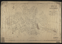 Contour plan of Grahamstown, 1934. Drawn by A.W.M. ; signed by W.A. Hodge, City Engineer. "War time regulations: this plan must not be removed from college premises under any circumstances" signed by E H Wied.
 -
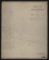 Contour plan of the City of Grahamstown; drawn by A.W.M. Checked by W.A. Hodge, June 1934