The Frontier Collections
Item set
- Title
- The Frontier Collections
- Description
-
The Frontier Collections are a curated collection of archival materials that document the turbulent and formative era of the Eastern Cape frontier. Spanning the late 18th to the early 20th century, these collections provide a multi-perspective view of the Frontier Wars (Xhosa Wars), the establishment of colonial administration, and the subsequent growth of settler infrastructure.
The collection is particularly noted for its focus on the "Frontier Country"—the region surrounding Makhanda (Grahamstown)—detailing the interplay between British settlers, Boer trekkers, and the Xhosa kingdoms. - Language
- English
- isiXhosa
- Type
- Collection
- Subject
- Frontier Wars
- 1820 Settlers
- Military History
- Colonial Architecture
- Xhosa History
- Urban Development
- Spatial Coverage
- Eastern Cape, South Africa (formerly the Cape Colony frontier)
- Temporal Coverage
- c. 1779 – 1910
- Format
- Manuscripts
- Lantern slides
- Cartographic materials
Items
-

-
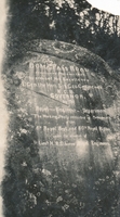 The inscription reads: “Boma Pass Road constructed December 1853 by order of His Excellency L’Gen. the Hon. Sir Geo. Cathcart K.C.B. Governor, by the Royal – Engineer Department. The working party consisted of Detachments of the 8th Regt. And the 60th Royal Rifles. Under the direction of Lieut HR Siborne Royal Engineers.
 -
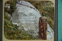 The wording on the stone is as follows – Boma Pass Road constructed December 1853 by order of His Excellency Lt. Gen. the Hon. Sir Geo. Cathcart KCB Governor, by the Royal Engineer Department. The working party consisted of Detachments of the 6th Royal Regt. and 60th Royal Rifles under the direction of Lieut. HR Siborne, Royal Engineers.
 -
-
-
-
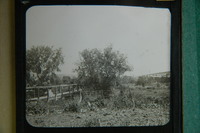
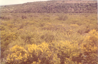 Acacia karroo trees in full flower.
 -
-
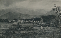
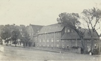
 Fort Willshire was built by the Royal Engineers under Lieutenant Colonel Thomas Willshire of the 38th Regiment, on the orders of Lord Charles Somerset, in 1819.
 -
 Fort Willshire was built by the Royal Engineers under Lieutenant Colonel Thomas Willshire of the 38th Regiment, on the orders of Lord Charles Somerset, in 1819.
 -
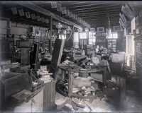
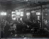 Glass negative : Views of the interior of Butler Bros., booksellers, stationers and importers, Cradock, possibly showing flood damage as the pictures show great confusion and mess.
 -
 Glass negative : Views of the interior of Butler Bros., booksellers, stationers and importers, Cradock, possibly showing flood damage as the pictures show great confusion and mess.
 -
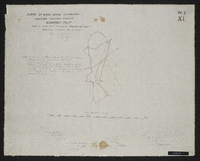
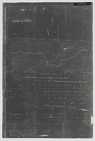 Diagram of the location … and extension thereof ceded to Capt. Thomas Butler's party, now the farm Melville Park, in the district of Albany; surveyed 13th June 1826 [by] Wm. J. Brown. Photo negative.
 -
-
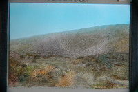
 Looking westwards from top of Hoho Peak (Pirie West Peak) over Protea thickets in immediate foreground to the mid-picture ridge covered in Cliffortia fynbos and which might once have held dense Protea subvestita and /or Protea multibracteata thickets. Some of the latter still growing below the subvestita thickets there. iNtaba knNdoda Peak in distance.
 -

-

-
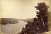
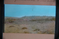
 "Fine pasture country uninhabited and considered neutral ground". Title 29th January 1944. Copied by Walter P. Jones, 21st July 1873.
 -
-
-
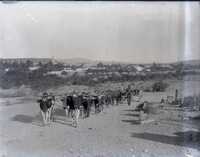
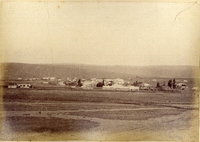
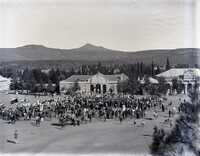 Glass negative : View of the celebration of Mafeking Day in Cradock, after the lifting of the Siege of Mafeking on 17 May 1900. Original holding envelope marked "Taken from G. B.'s roof".
 -
-
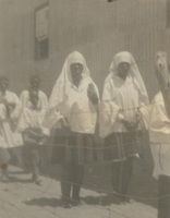 A photograph album compiled by Mary Butler, containing photographs of Wayfarers, Sunbeams and Pathfinders, mostly in Cradock. Two newspaper clippings and a handwritten concert programme included. There are three photographs of Rev. James Arthur Calata's young daughters, and he himself is included in two photographs. This photograph showing a choir consisting of young African girls at St James Mission in Cradock, Eastern Cape. Rev James Arthur Calata was the priest-in-charge of St James Anglican Mission Church and also school mananager of the St James Mission School. He had deep interest in the education of an African child. Amongst the things he did for the mission school was to re-create it into a social sphere of transformation, and established a church choir
 -
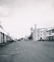
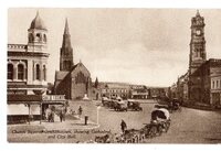 A sepia-toned postcard or print depicting Church Square in Grahamstown. The scene shows the Anglican Cathedral of St. Michael and St. George in the center and the City Hall clock tower on the right. The foreground captures a transition in transport, featuring both motorised vehicles parked in a row and a traditional donkey or ox-drawn wagon in the lower right. The "Bon Marche" building is visible on the far left.
 -
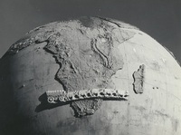 The Karel Landman Monument in the Sundays River Valley Rural, Eastern Cape, was designed by Gerard Moerdyk and built by the Lupini Brothers. It was unveiled on 16 December 1939 by W A L Landman. It honours Karel Landman who farmed in this area until 1837 when he became a leader in the Great Trek. He led a party of 180 Trekkers and their servants on a trek of 885 kilometres into Natal where he was prominent in several battles with the Zulus and he was second in command of the Boer forces at the pivotal battle of Blood River. The commemoration of Karel Landman and his trek, in this 3m globe with an ox wagon traversing it, was an initiative of the National Party and the councils of the Dutch Reformed Church in two neighbouring villages, Alexandria and Paterson. Legend has it that the councils could not agree which village should 'host’ the monument, so it was placed on this remote koppie overlooking the surrounding countryside, between the two villages.,F G Butler (donor)