The Frontier Collections
Item set
- Title
- The Frontier Collections
- Description
-
The Frontier Collections are a curated collection of archival materials that document the turbulent and formative era of the Eastern Cape frontier. Spanning the late 18th to the early 20th century, these collections provide a multi-perspective view of the Frontier Wars (Xhosa Wars), the establishment of colonial administration, and the subsequent growth of settler infrastructure.
The collection is particularly noted for its focus on the "Frontier Country"—the region surrounding Makhanda (Grahamstown)—detailing the interplay between British settlers, Boer trekkers, and the Xhosa kingdoms. - Language
- English
- isiXhosa
- Type
- Collection
- Subject
- Frontier Wars
- 1820 Settlers
- Military History
- Colonial Architecture
- Xhosa History
- Urban Development
- Spatial Coverage
- Eastern Cape, South Africa (formerly the Cape Colony frontier)
- Temporal Coverage
- c. 1779 – 1910
- Format
- Manuscripts
- Lantern slides
- Cartographic materials
Items
-
-
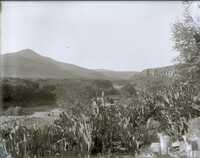
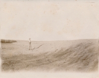 Photograph of a man admiring vast landscapes in "Port Alfred"
 -
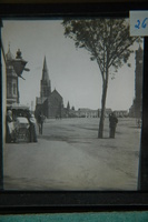
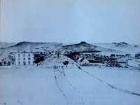 Facebook post (dated 22 February 2021) by Gareth Angelbeck: "A reproduction of a pen-and-ink sketch by W. Guybon Atherstone from the steps of the Drostdy looking down High Street, dated 3 May 1830. The three-storied building at the corner of High Street (now Major Frasiers) is known to have been built by Pieter Retief. All subsequent illustrations show it with two stories only, and the alteration must have taken place several decades before the advent of photography. The sketch also shows an open water furrow, leading from the bottom right corner to the top of High Street. This was the public water supply of the town in 1830, which was led to open tanks at various points in the town. Colonel Graham's mimosa tree is shown, in the middle of High Street, a short distance from St. George's Church (later, the Cathedral). This tree, marking the traditional spot where the decision to found Grahamstown was made on 14 August 1812, was destroyed in a gale in 1844. (Ref- Grahamstown in Early Photographs, F van der Riet, David Philip pub, CT, 1974)."
 -
-
-
 F G Butler (donor)
 -
 Fort Brown, built by Andrew Geddes Bain in 1836 on a site previously known as Hermanus Kraal.
 -
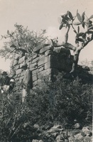 View of a corner of the ruins of Fort Willshire and detail of the stone work showing method of construction. Una Long : photographer
 -
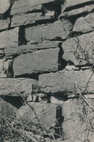 View of a corner of the ruins of Fort Willshire and detail of the stone work showing method of construction. Una Long : photographer
 -
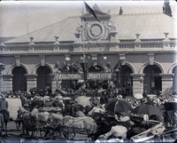
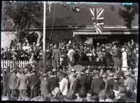 Glass negative : View of a crowd surrounding an unidentified man and woman standing on an outdoor platform, with Union Jack flags hanging above them. A banner proclaiming 'Welkom' is in the background.
 -
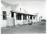 Glass negative : Set of 5 negatives: Four views of a farm dam and one view of a [farm] house: River View, taken in January 1932. Possibly connected to the Hyam family of Cradock.
 -
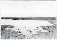 Glass negative : Set of 5 negatives: Four views of a farm dam and one view of a [farm] house: River View, taken in January 1932. Possibly connected to the Hyam family of Cradock.
 -
-
-
-
-
-
-
-
 Added to the lantern slide collection by Dr Charles GE Cory, son of Sir George Cory.
 -
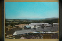
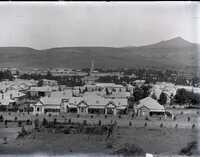 Glass negative : View of Cradock showing vegetable gardens in the foreground, Victorian houses and a church spire in the background.
 -
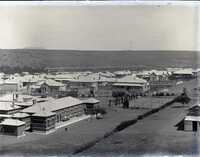 Glass negative : View of Cradock showing a tennis court, a back view of the Queen's Central Hospital, and houses in the background.
 -
 Glass negative : View of Cradock, 1902, showing part of the Queen's Central Hospital, and houses in the background.
 -
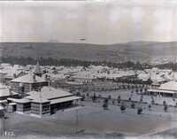
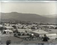 Glass negative : View of Cradock showing houses taken from an elevated position.
 -