The Frontier Collections
Item set
- Title
- The Frontier Collections
- Description
-
The Frontier Collections are a curated collection of archival materials that document the turbulent and formative era of the Eastern Cape frontier. Spanning the late 18th to the early 20th century, these collections provide a multi-perspective view of the Frontier Wars (Xhosa Wars), the establishment of colonial administration, and the subsequent growth of settler infrastructure.
The collection is particularly noted for its focus on the "Frontier Country"—the region surrounding Makhanda (Grahamstown)—detailing the interplay between British settlers, Boer trekkers, and the Xhosa kingdoms. - Language
- English
- isiXhosa
- Type
- Collection
- Subject
- Frontier Wars
- 1820 Settlers
- Military History
- Colonial Architecture
- Xhosa History
- Urban Development
- Spatial Coverage
- Eastern Cape, South Africa (formerly the Cape Colony frontier)
- Temporal Coverage
- c. 1779 – 1910
- Format
- Manuscripts
- Lantern slides
- Cartographic materials
Items
-
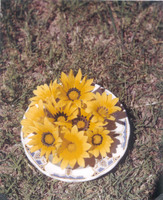 9 different centres from the same field of Gazania.
 -
 Note the variable centre.
 -
-
 [Imperial map of South Africa] : Kingwilliamstown compiled by the [British Military] Intelligence Department, 1900?
 -
-
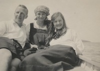 Photograph of three people
 -
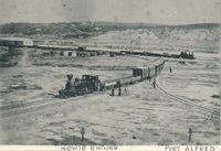 Note on the bottom: “Kowie Engine” and “Port Alfred”. d. Note on the back: “The first two engines for 3’-6” gauge working between Port Alfred and Grahamstown Landed by SS Rothsay May 20th 1882 – Ran first trial trip from Port Alfred for 16 miles pn the 25th July 1882. Engine made my the Hunsletics & Leeds. The Kowie Engine was the passing engine [illegible] 22 Tom “Grahamstown” “Port Alfred” engine for Goods working washing 25 Tom or “Kowie”".,Kowie engine at Port Alfred.
 -
-
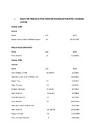 A collection of Land Grants (both Freehold and Perpetual Quitrent) and transfers/title deeds for the Stutterheim/King William's Town area. Although these are predominantly in the names of German immigrants and British German Legion settlers, there are also some grants in Freehold for Xhosa people, as well as grants in Perpetual Quitrent for men at the mission stations of Bethel, Umgwali and Wartburg. Most of the documents are accompanied by diagrams of the land in question.
 -
-
-
-
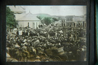 The foundation stone for the chancel was laid by the Governor of the Cape Colony, Sir Henry Loch, on 29 January 1890, and the completed structure was consecrated in 1893. (The photographer for this image was Hepburn.)
 -
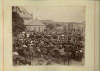 Laying of the foundation stone of the chancel of Cathedral of St Michael and St George, Grahamstown.View from south side of Church Square of the laying of the foundation stone of the chancel of the Cathedral of St Michael and St George by the Governor, Sir Henry Loch, on 29 January 1890. A photographer from Barraud Brothers is visible in the background.
 -
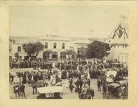 A note on the verso reads ' The laying of the foundation stone of the chancel of the Cathedral of St Michael and St George, Grahamstown, by His Excellency, Sir Henry Loch, GCMG KCB, Wednesday, 29th January 1890'. It shows a view from the north side of Church Square.
 -
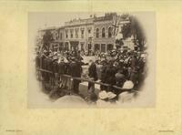 View from the north side of Church Square showing the laying of the foundation stone of the chancel of the Cathedral of St Michael and St George by the Governor, Sir Henry Loch, on 29 January 1890. The camera of F. W. Hepburn is visible in the upper left window of 'T.H. Parker', a stone building in the background.,Donated by Martin Plaut, 2015
 -
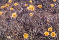
 The Scaly-throated Honeyguides call-site was in the dense tall patch in the stream bed.
 -
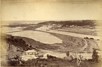
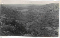
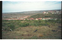 Nice houses in centre photo overlooking urban sprawl beyond. Bethelsdorp Saltpan near top of photo, thinned out original veld in foreground in which Sanseviera plants thrive. More good type homes behind photographer.
 -
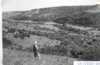 The Scaly-throated Honeyguide ranged over the whole area but mostly in the forests and along bushy streams.
 -
-
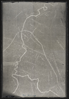 Plan of land around Lovedale; some of it marked for "alienation" - owners of some property shown. (Negative) Photograph of origincal manuscript, 1875.
 -
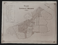 Plan of Lovedale Mission 1902. Photograph.
 -
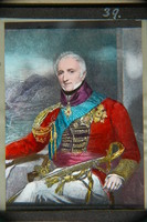 Sir Rufane Shawe Donkin, 1772- 1841, Acting Governor of the Cape 1820-1821.
 -
-
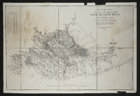 Lithographed by James Wyld, geographer to the Queen 457 Strand, 11 & 12 Charing Cross S.W. and 2 Royal Exchange E.C.,1849. Note: the position of the military posts are marked by a red circle, and the present colonial boundary is marked with a red tint. Copy of the original.