Pre 1910 Maps
Item set
- Title
- Pre 1910 Maps
- Alternative Title
- Cory Library Historical Map Collection
- Description
-
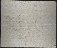
This digital collection comprises 95 historical maps and plans created before 1910, drawn from the cartographic holdings of the Cory Library for Humanities Research at Rhodes University. The maps encompass a range of colonial-era topographic surveys, military sketches, regional cartographic representations, and early colonial settlement plans, covering parts of Southern Africa, particularly the Eastern Cape, Cape Colony, and adjacent territories. The collection includes manuscript plans and lithographed maps, many of which were compiled under the auspices of colonial government departments, military engineers, and early surveyors. It reflects early geographical knowledge and spatial organisation during the 19th century and the period just before the turn of the 20th century, including maps of military engagements (e.g., Spion Kop, 1900), indigenous territories, settlement expansions, and early infrastructural landscapes.
digitalarchives.ru.ac.za
These pre-1910 maps are vital resources for historians, geographers, archaeologists, and researchers interested in colonial cartography, frontier history, military history, settlement patterns, indigenous landscapes and early colonial administration in South Africa. Each map provides unique insights into historical spatial understandings and territorial control at a formative stage in South African cartographic history. - Language
- English
- Type
- Collection
- Format
- Digital Images (various scans) - Various map scales and projections
- Spatial Coverage
- Southern Africa (includes Cape Colony divisions, Transkei, Natal region, etc.)
- Temporal Coverage
- 19th century – very early 20th century (pre-1910)
- Relation
- Part of the Cory Map Collection; Related to other map sets such as 1910-pre-1994 Maps
- Extent
- 95 map items (digital)
Items
-
-
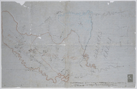
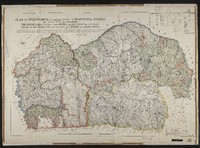
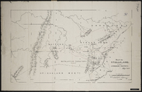 Map of Stellaland showing the surrounding territories signed by R.A. Lavertine,[1884]
 -
 Lithographed by James Wyld, geographer to the Queen 457 Strand, 11 & 12 Charing Cross S.W. and 2 Royal Exchange E.C.,1849. Note: the position of the military posts are marked by a red circle, and the present colonial boundary is marked with a red tint. Copy of the original.
 -
 Map of the district of Matatiele; compiled from maps, plans and diagrams filed in the Surveyor General's Office, Cape Town [by] C. Neumann Thomas.
 -
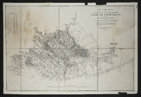
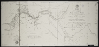
 Map of the Eastern frontier of the Cape Colony, compiled by Henry Hall, a draughtsman to the Royal engineers, Cape Town, from military and other surveys, and dedicated by permission to J.F. Burgoyne. Published London, Edward Stanford.
 -
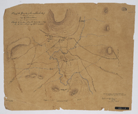
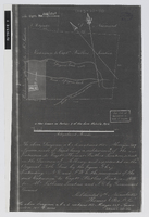 Diagram of a subdivision of the extension to Capt Thomas Butler's location, now known as portion 3 of the farm Melville Park, situated in the division of Albany, subdivided 9th November 1843 [by] Thomas Okes. Photograph negative.
 -
 Missionary map of the Queenstown district showing Methodist, Anglican, Moravian, United Presbyterian and Free Church of Scotland stations.
 -
 [Imperial map of South Africa] : Murraysburg compiled and lithographed by Mapping Section F.I.D. Cape Town under the superintendance of Capt. P.H. Du P. Casgrain ... from farm surveys and all other available information, [Wood and Ortlepp] [1900].
 -
 Copied from plan no. 1826, J.C.H.G. draftsman. With lists of grantees of lots.
 -
 Outline maps of the territory between the Kei and Bashee Rivers. Some mission stations marked. 2 scales given on MP 1456 (1" = c.5 miles and 1½" = c.5 miles); no scale given on MP 1457.
 -
 Respectfully presented to the Colonial Government with a memoir signed by R. Moffat Jun. .. Kuruman, Jan., 1857.
 -
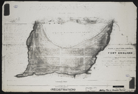 Plan of a section of ground situated between Fort England and the property of Mr John Carlisle, shewing its subdivision into allotments form actual survey executed by order of Government in the months of January and February 1857…
 -
 Surveyed by Lt. Williams ; drawn by H.W. Piers, Jan. 1839.
 -
 Letterbook copy of a plan of Lovedale, annotated 1846, changed to 1856.
 -
 Plan of Port Elizabeth (Cape Colony). Supplement to Donaldson and Hill's Eastern Province Cape Colony directory, 1904.
 -
 Divided and planned by Joh. H. Fort (1864) with later transfer subdivisions by W.R. Piers (1880).
 -
-
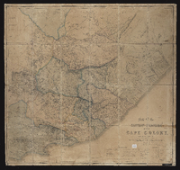
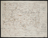
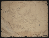
 Plan of Territories formerly known as Kaffraria proper, lying between the following boundaries, The Quathlamba range on the north, the sea coast on the east, Natal on the north east and the Kei and Indwe on south west. Compiled by plans of surveys by surveyors C.P. Watermeyer; Fletcher; MacDonald, Schunke, Tilney, Norris, Greeff, Greathead, F. Watermeyer; Erskine, Hughes R.N., Changuion, Prithcard and O. Mehliss, and military sketches by Messrs Colley & Grant & the Intelligence Branch of the Quartermaster General's Department. Includes approximate table of distances from Kokstad to several magistracies and Umtata. Map signed by A (Abraham) de Smidt, surveyor general.
 -
-
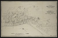
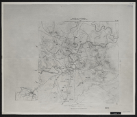
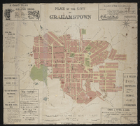 Plan of the city of Grahamstown; framed from survey and compilation in 1887 by E.D. Barker, GLS and R.S. Fairbridge GLS … by Ernest Grubb, City Engineer. "London Geographical Institute".
 -
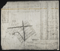
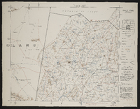
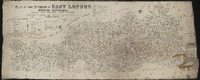 Plan of the division of East London, British Kaffraria, taken from general plans framed by D. Macdonald, A. E. Murray, E.T. Cooper, H.E.R. Bright, J.X. Merriman, J. Powell, E. Griffiths, W.D. Dumbleton, C. Watermeyer, H. Bryant, Lieutenant Colley, C.A. Smith and C.J. Gray, Government Surveyors; Compiled by C. Neumann Thomas, Surveyor General's Office, Cape Town, 1867. Scale 1" = 4000 Cape Roods. 1 sheet 30" x 72". Showing Field Cornetcy areas and Leased Lots.
 -
-
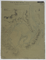
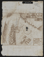
 Plan shewing military defences of King Williams Town; [by] Geo. Newey.
 -
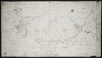
 Relief of Ladysmith : area of operations 14th to 28th February 1900 ; height in feet above Colenson station which is 3156 feet above sea level. Ordnance Survey, Southampton.
 -
 [Imperial map of South Africa] : Salt Pan compiled and lithographed by Mapping Section F.I.D. Cape Town under the superintendance of Capt. P.H. Du P. Casgrain ... from farm surveys and all other available information, [Wood and Ortlepp] [1900] 3rd edition.