1910 - pre-1994 Map Collection
Item set
- Alternative Title
- Cory Library Historical Map Collection
- Description
-
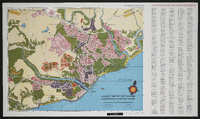
This digital collection comprises 119 historical maps housed in the Cory Library for Humanities Research at Rhodes University, dating from 1910 up to the early 1990s. The maps encompass a wide range of geographical and thematic materials, including urban plans, railway networks, regional studies, survey charts, and specialised maps used for planning and statistical purposes. Key map types include standard railway maps of South Africa, municipal plans (such as early Grahamstown and Port Alfred layouts), topographic and aeronautical charts, and maps associated with academic theses and regional planning documents.
The maps reflect major socio-economic, infrastructural, and administrative developments in South Africa and its Eastern Cape region over eight decades. They are invaluable resources for researchers working in urban history, transportation history, regional planning, colonial and post-colonial studies, and environmental change. This collection supports investigation into historical spatial relationships, transportation networks, and settlement patterns across different periods of the 20th century. - Date Issued
- 1910 - 1994
- Language
- English
- Type
- Collection
- Format
- Digital Images (various scans) - Various map scales and projections
- Spatial Coverage
- South Africa
- Temporal Coverage
- 20th Century (1910 – pre-1994)
Items
-
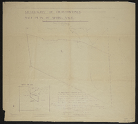
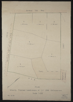 Plan showing proposed subdivisions of Erf 2918, Grahamstown, September 1977.
 -
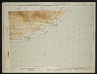 Port Elizabeth (3421). Aeronautical chart of Port Elizabeth region, South Africa. Compiled and drawn by the Trigonometrical Survey Office, 1953. Reprinted by the Government Printer in 1956. Hypsometric tints for Africa south of 16° south latitude. Elevations in feet. T.S.O. 607/836. Topographic base, 1952. First edition.
 -
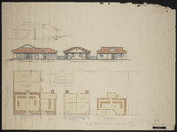
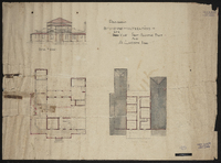
 Proposed bathing Pavilion for Port Alfred Municipality.
 -
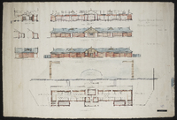
 Proposed buildings on Block no 2968 Port Alfred for F.H. Schoeder, Esqr.
 -
 Proposed extensions and alterations to Sea View Port Alfred East for A. Larsen Esq. One of nine plans from the Scott Collection, 1922-1947.
 -
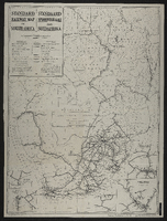
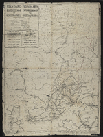
 Map of the Union showing railway lines and stations ; designed and drawn in the Trigonometrical Survey Office. Printed in the Union of South Africa by the Government Printer, Pretoria, 1946.
 -
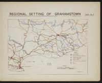 Map 5 in the map album accompanying the thesis by Hilstan Lett Watts, "Grahamstown : a socio-ecological study of a small South African town", Rhodes University thesis, 1957. Map signed 1955.
 -
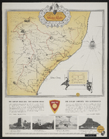
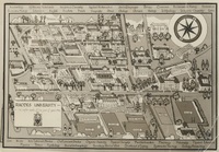 "Map" of Rhodes University with buildings and venues labled, as well as list of departments listed in top and bottom frames.
 -

-
 Sale plan of a portion of the farm Spring Vale commonly known as Featherstone's Kloof.R. Brown, City Enginner, Oct. 1929.
 -
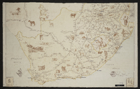
 Dunlop gold seal trek bumper badge map.
 -
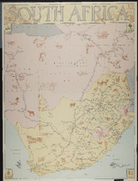 Map showing places of interest, mines and minerals, and agricultural products. South Africa. 1947.
 -
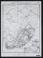 Photo-lithographed at the Government Printing Works, Pretoria.Revised 1 March 1916.
 -
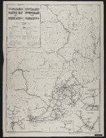 Photo-lithographed at the Government Printing Works, Pretoria, 1950. Compiled in the Office of the Chief Civil Engineer, S.A.R., Johannesburg
 -
 Drawn in the office of the Chief Civil Engineer, SAR, Johannesburg. Compiled on the basis of Bonne's projection (Central Meridian 25 East Longitude.
 -
 Drawn in the office of the Chief Civil Engineer, SAR, Johannesburg. Photo-lithographed at the Government Printing Works, Pretoria,[1925]. Two undated railway maps appended.
 -

-
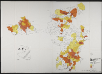 Maps to accompany "Statistical base for planning service centres in Transkei's north-west region" by Osmond Lange Vandeverre Haarhoff Goldswain and Burger, architects and regional planners. For the Department of Commerce, Industry and Tourism, Republic of Transkei. Map 1 north west region, Map 2 north east region.
 -
 Tourist map of East London showing places of interest. Produced by the East London Publicity Association in conjunction with Shell South Africa (Pty) Limited. Compiled and drawn by B. L. Walton, October 1955.