1910 - pre-1994 Map Collection
Item set
- Alternative Title
- Cory Library Historical Map Collection
- Description
-
This digital collection comprises 119 historical maps housed in the Cory Library for Humanities Research at Rhodes University, dating from 1910 up to the early 1990s. The maps encompass a wide range of geographical and thematic materials, including urban plans, railway networks, regional studies, survey charts, and specialised maps used for planning and statistical purposes. Key map types include standard railway maps of South Africa, municipal plans (such as early Grahamstown and Port Alfred layouts), topographic and aeronautical charts, and maps associated with academic theses and regional planning documents.
The maps reflect major socio-economic, infrastructural, and administrative developments in South Africa and its Eastern Cape region over eight decades. They are invaluable resources for researchers working in urban history, transportation history, regional planning, colonial and post-colonial studies, and environmental change. This collection supports investigation into historical spatial relationships, transportation networks, and settlement patterns across different periods of the 20th century. - Date Issued
- 1910 - 1994
- Language
- English
- Type
- Collection
- Format
- Digital Images (various scans) - Various map scales and projections
- Spatial Coverage
- South Africa
- Temporal Coverage
- 20th Century (1910 – pre-1994)
Items
-
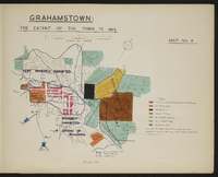 Map 3 in the map album accompanying the thesis by Hilstan Lett Watts, "Grahamstown : a socio-ecological study of a small South African town", Rhodes University thesis, 1957. Map signed 1955. Based on an original map in the Cory Library, Rhodes University.
 -
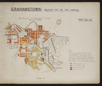 Map 20 in the map album accompanying the thesis by Hilstan Lett Watts, "Grahamstown : a socio-ecological study of a small South African town", Rhodes University thesis, 1957. Map signed 1955. The data are from the sample survey of the European area of Grahamstown.
 -
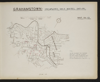 Map 10 in the map album accompanying the thesis by Hilstan Lett Watts, "Grahamstown : a socio-ecological study of a small South African town", Rhodes University thesis, 1957. Map signed 1955. The map represents the total number of unemployed male whites registered with the Labour Office in Grahamstown during 1947-1951.
 -
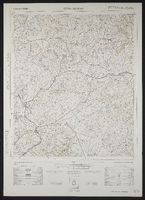
 3228 Kei Mouth, South Africa 1:25000 sheet. Compiled and drawn in 1960 by the Trigonometric Survey Office. Magesterial districts as at August 1960. T.S.O. 404/971. (Saamgestel in 1960 en geteken in 1960 deur die Driehokesmatings Kantoor.)
 -
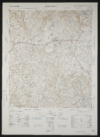
 3327 DA Kei Road, South Africa 1:50000 sheet, first edition. Air photography 1953, surveyed in 1960, drawn in 1962 by the Trigonometric Survey Office. T.S.O. 200/1635. (Lugfotografie 1953, opgemeet in 1960, en geteken in 1962 deur die Driehokesmatings Kantoor.),1st edition
 -
 3028 Kokstad, South Africa 1:25000 sheet. Compiled and drawn in 1959 by the Trigonometric Survey Office. Magisterial districts as at July 1964. T.S.O. 404/958. (Saamgestel en geteken in 1960 deur die Driehokesmatings Kantoor.)
 -
 3227 DB Komga, South Africa 1:50000 sheet, first edition. Air photography 1953, surveyed in 1960, drawn in 1962 by the Trigonometric Survey Office. T.S.O. 200/1620. (Lugfotografie 1953, opgemeet in 1960, en geteken in 1962 deur die Driehokesmatings Kantoor.),1st edition
 -
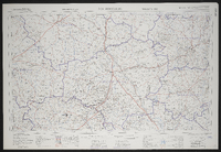
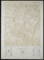
 Photograph of a map of the area around Ladysmith, mainly south of the town.Probably a copy of part of a general topographical series.
 -
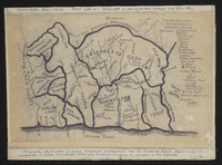
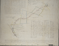 Diagram of the land between the Langholme estates and Martindale station … which is to be used by the African Canning and Packing Corporation Ltd for railway purposes … [by] Rex Sucker… Grahamstown, D.G. Iverach, 25.3.1923 ; approved by the Surveyor General.
 -
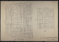
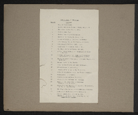 List of maps in the map album accompanying the thesis by Hilstan Lett Watts, "Grahamstown : a socio-ecological study of a small South African town", Rhodes University thesis, 1957.
 -
 3018 Loeriesfontein, South Africa 1:25000 sheet. Compiled and drawn in 1961 by the Trigonometric Survey Office. Magisterial districts as at May 1961. T.S.O. 404/953. (Saamgestel en geteken in 1960 deur die Driehokesmatings Kantoor.)
 -
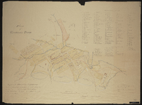
 Plan of land around Lovedale; some of it marked for "alienation" - owners of some property shown. (Negative) Photograph of origincal manuscript, 1875.
 -
-
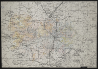
 Map of the Great Fish River Irrigation Board. C.H. Hughes, circle engineer; A.D. Lewis, Director of Irrigation.
 -
 3124 Middelburg, South Africa 1:25000 sheet. Compiled and drawn in 1960 by the Trigonometric Survey Office. Magisterial districts as at May 1960. T.S.O. 404/963. (Saamgestel en geteken in 1960 deur die Driehokesmatings Kantoor.)
 -
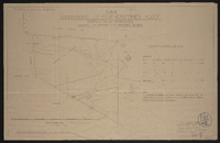
 Municipality of the city of Grahamstown. Parks. Old cemetery. Feb 1987. Showing Wesleyan, Anglican, Baptis, Presbyterian, Roman Catholic.
 -
 Palingkloof 3226AA. South Africa 1:50000 sheet. Air photography 1943. Field survey 1945. Drawn by the Trigonometric Survey in 1953. T.S.O. 200/1048. (Lugfotografie 1943. Veldopmeting 1945. Saamgestel en geteken in 1953 deur die Driehokesmatings Kantoor.) First edition
 -
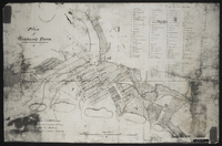
 "Plan probably drawn 1824. Copied by E. Lewcock, Sept. 1962. Original in Albany Museum, Courtesy Surveyor-General."
 -
 Plan of Grahamstown noting owners of erven 1 to 20 and at Cape Corps Barracks (Fort England). Duplicate of MP145. The map is unsigned and a photocopy. Given to the Cory Library by Mr. K.S. Hunt
 -
 Map 1 in the map album accompanying the thesis by Hilstan Lett Watts, "Grahamstown : a socio-ecological study of a small South African town", Rhodes University thesis, 1957. Map signed 1955. This map is based on a municipal map, with necessary corrections. Street widths are exaggerated for the purpose of clarity. The street pattern shown is for the town in 1951. The so-called "Hottentot Village" is today the Coloured location.
 -
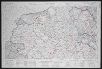
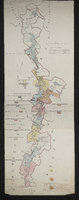
 Plan of Territories formerly known as Kaffraria proper: simplified handdrawn copy of the 1884 map of the territories formerly known as Kaffraria, with additional information inserted by Alfred William Burton. Surveyors C.P. Watermeyer; Fletcher ; MacDonald, Schunke, Tilney, Norris, Greeff, Greathead, F. Watermeyer; Erskine, Hughes R.N., Changuion, Pritchard and O. Mehliss, and military sketches by Messrs Colley and Grant and the Intelligence Branch of the Quartermaster General's Department. Photocopy stuck on card. Transkeian territories. First produced in 1884 by 14 surveyors and 3 others.See MP 307, L (77) d 1 for the original map by fourteen surveyors and Military sketches.
 -
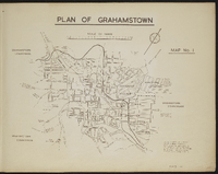
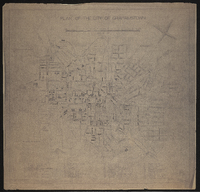 Plan of the City of Grahamstown, 1934 prepared by A W Marshall, City Engineer's Department.
 -
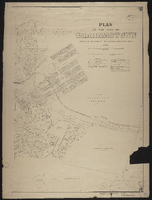 Plan of the City of Grahamstown, 1924 compiled in the Office of the Surveyor General, Cape Town. Compiled from plans and diagrams filed in the office of the Registrar of Deeds and Surveyor General Cape Town.
 -

-
 Drawn by A.W.M. ; signed by W.A. Hodge, City Engineer.