1910 - pre-1994 Map Collection
Item set
- Alternative Title
- Cory Library Historical Map Collection
- Description
-
This digital collection comprises 119 historical maps housed in the Cory Library for Humanities Research at Rhodes University, dating from 1910 up to the early 1990s. The maps encompass a wide range of geographical and thematic materials, including urban plans, railway networks, regional studies, survey charts, and specialised maps used for planning and statistical purposes. Key map types include standard railway maps of South Africa, municipal plans (such as early Grahamstown and Port Alfred layouts), topographic and aeronautical charts, and maps associated with academic theses and regional planning documents.
The maps reflect major socio-economic, infrastructural, and administrative developments in South Africa and its Eastern Cape region over eight decades. They are invaluable resources for researchers working in urban history, transportation history, regional planning, colonial and post-colonial studies, and environmental change. This collection supports investigation into historical spatial relationships, transportation networks, and settlement patterns across different periods of the 20th century. - Date Issued
- 1910 - 1994
- Language
- English
- Type
- Collection
- Format
- Digital Images (various scans) - Various map scales and projections
- Spatial Coverage
- South Africa
- Temporal Coverage
- 20th Century (1910 – pre-1994)
Items
-
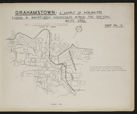
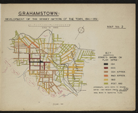
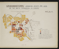
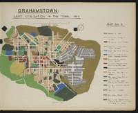
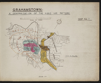 Map 7 in the map album accompanying the thesis by Hilstan Lett Watts, "Grahamstown : a socio-ecological study of a small South African town", Rhodes University thesis, 1957. Map signed 1955.
 -
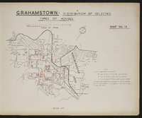
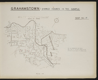
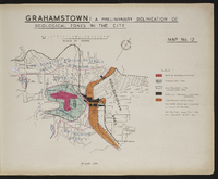 Map 12 in the map album accompanying the thesis by Hilstan Lett Watts, "Grahamstown : a socio-ecological study of a small South African town", Rhodes University thesis, 1957. Map signed 1955. The data are from the sample survey of the European area of Grahamstown.
 -
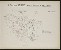
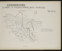 Map 19 in the map album accompanying the thesis by Hilstan Lett Watts, "Grahamstown : a socio-ecological study of a small South African town", Rhodes University thesis, 1957. Map signed 1955. The data are from the sample survey of the European area of Grahamstown.
 -
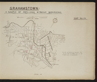 Map 26 in the map album accompanying the thesis by Hilstan Lett Watts, "Grahamstown : a socio-ecological study of a small South African town", Rhodes University thesis, 1957. Map signed 1955. The data are from the sample survey of the European area of Grahamstown.
 -
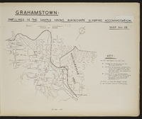
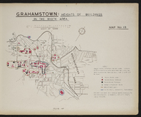
 Map 13 in the map album accompanying the thesis by Hilstan Lett Watts, "Grahamstown : a socio-ecological study of a small South African town", Rhodes University thesis, 1957. Map signed 1955. The data are from the sample survey of the European (white) area of Grahamstown.
 -
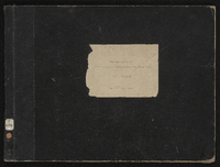 Cover of the map album accompanying the thesis by Hilstan Lett Watts, "Grahamstown : a socio-ecological study of a small South African town", Rhodes University thesis, 1957.
 -
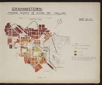 Map 22 in the map album accompanying the thesis by Hilstan Lett Watts, "Grahamstown : a socio-ecological study of a small South African town", Rhodes University thesis, 1957. Map signed 1955. The data are based on mean values calculated for each street, using survey sample data for the number of rooms per dwelling.
 -
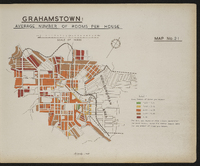 Map 21 in the map album accompanying the thesis by Hilstan Lett Watts, "Grahamstown : a socio-ecological study of a small South African town", Rhodes University thesis, 1957. Map signed 1955. The data are based on mean values calculated for each street, using survey sample data for the number of rooms per house.
 -
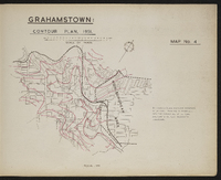 Map 4 in the map album accompanying the thesis by Hilstan Lett Watts, "Grahamstown : a socio-ecological study of a small South African town", Rhodes University thesis, 1957. Map signed 1955. This map is based on a detailed contour map of the town, prepared by the City Enginner's Department.
 -
 Map 2 in the map album accompanying the thesis by Hilstan Lett Watts, "Grahamstown : a socio-ecological study of a small South African town" ; Rhodes University thesis, 1957. Map signed 1955.
 -
 Map 16 in the map album accompanying the thesis by Hilstan Lett Watts, "Grahamstown : a socio-ecological study of a small South African town", Rhodes University thesis, 1957. Map signed 1955. Data are based on a special survey conducted by the investigator. A complete and not a sample survey was made.
 -
 Map 25 in the map album accompanying the thesis by Hilstan Lett Watts, "Grahamstown : a socio-ecological study of a small South African town", Rhodes University thesis, 1957. Map signed 1955. The data are from the sample survey of the European area of Grahamstown.
 -
 Map 14 in the map album accompanying the thesis by Hilstan Lett Watts, "Grahamstown : a socio-ecological study of a small South African town", Rhodes University thesis, 1957. Map signed 1955. The data are based on number of persons per street, estimated on the basis of the survey sample, and the total acreage covered by housing plots in the street (excluding unoccupied plots) obtained from the municipal valuation roll for Grahamstown, 1953.
 -
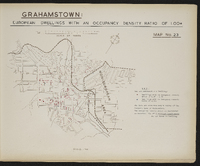 Map 23 in the map album accompanying the thesis by Hilstan Lett Watts, "Grahamstown : a socio-ecological study of a small South African town", Rhodes University thesis, 1957. Map signed 1955. The data are from the sample survey of the European area of Grahamstown
 -
 Map 18 in the map album accompanying the thesis by Hilstan Lett Watts, "Grahamstown : a socio-ecological study of a small South African town", Rhodes University thesis, 1957. Map signed 1955. Data are based on a special survey conducted by the investigator. A complete and not a sample survey was made.
 -
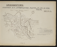 Map 24 in the map album accompanying the thesis by Hilstan Lett Watts, "Grahamstown : a socio-ecological study of a small South African town", Rhodes University thesis, 1957. Map signed 1955. The data are from the sample survey of the European area of Grahamstown.
 -
 Map 6 in the map album accompanying the thesis by Hilstan Lett Watts, "Grahamstown : a socio-ecological study of a small South African town", Rhodes University thesis, 1957. Map signed 1955.
 -
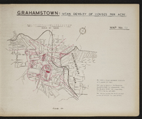 Map 11 in the map album accompanying the thesis by Hilstan Lett Watts, "Grahamstown : a socio-ecological study of a small South African town", Rhodes University thesis, 1957. This map is based on the municipal valuation roll for Grahamstown, 1953. Map signed 1955.
 -
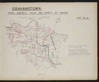 Map 8 in the map album accompanying the thesis by Hilstan Lett Watts, "Grahamstown : a socio-ecological study of a small South African town", Rhodes University thesis, 1957. Map signed 1955. This map is based on the Municipal Valuation Roll for Grahamstown, 1953. The rateable values are based on mean values calculated for each street. The map represents parameters as sampling was not used.
 -
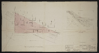 Grahamstown : Plan showing portion of Cemetery required by S.A.R. ; plan aantonende gedeelte van begraafplek deur S.A.S. Signed by District Engineer, 26.4.54 ; System engineer 30.4.54 ; System manager 3.5.54 ; scale as shown 26.4.54 ; No PE 138, A 9.
 -
 Map 15 in the map album accompanying the thesis by Hilstan Lett Watts, "Grahamstown : a socio-ecological study of a small South African town", Rhodes University thesis, 1957. Map signed 1955. The data are from the sample survey of the European area of Grahamstown.
 -
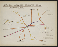 Diagram 6 in the map album accompanying the thesis by Hilstan Lett Watts, "Grahamstown : a socio-ecological study of a small South African town", Rhodes University thesis, 1957. Map signed 1955. This diagram is based on a S.A.R. diagram and is not to scale. Bus service frequencies are for scheduled regular services only and are taken from the 1953 S.A.R. timetable (no. 150, 15th June 1953).
 -
 Map 17 in the map album accompanying the thesis by Hilstan Lett Watts, "Grahamstown : a socio-ecological study of a small South African town", Rhodes University thesis, 1957. Map signed 1955. Data are from a sample survey of the European area of Grahamstown.
 -
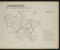 Map 9 in the map album accompanying the thesis by Hilstan Lett Watts, "Grahamstown : a socio-ecological study of a small South African town", Rhodes University thesis, 1957. Map signed 1955. Data obtained from the Department of Social Welfare's Office in Grahamstown, and school records of the Cape Provincial Education Department ; also from the Magistrate's Court records.
 -
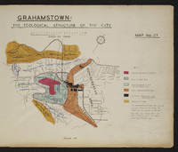 Map 27 in the map album accompanying the thesis by Hilstan Lett Watts, "Grahamstown : a socio-ecological study of a small South African town", Rhodes University thesis, 1957. Map signed 1955.