1910 - pre-1994 Map Collection
Item set
- Alternative Title
- Cory Library Historical Map Collection
- Description
-
This digital collection comprises 119 historical maps housed in the Cory Library for Humanities Research at Rhodes University, dating from 1910 up to the early 1990s. The maps encompass a wide range of geographical and thematic materials, including urban plans, railway networks, regional studies, survey charts, and specialised maps used for planning and statistical purposes. Key map types include standard railway maps of South Africa, municipal plans (such as early Grahamstown and Port Alfred layouts), topographic and aeronautical charts, and maps associated with academic theses and regional planning documents.
The maps reflect major socio-economic, infrastructural, and administrative developments in South Africa and its Eastern Cape region over eight decades. They are invaluable resources for researchers working in urban history, transportation history, regional planning, colonial and post-colonial studies, and environmental change. This collection supports investigation into historical spatial relationships, transportation networks, and settlement patterns across different periods of the 20th century. - Date Issued
- 1910 - 1994
- Language
- English
- Type
- Collection
- Format
- Digital Images (various scans) - Various map scales and projections
- Spatial Coverage
- South Africa
- Temporal Coverage
- 20th Century (1910 – pre-1994)
Items
-
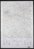
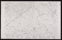
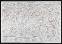
 3227DC Berlin, South Africa 1:50000 sheet. Air photography 1964. Surveyed in 1971 and drawn in 1973 by the Trigonometrical Survey Office. Lugfotografie 1964. Opgemeet in 1971 en geteken in 1973 deur die Driehoeksmeting Kantoor. T.S.O. 200/5495. Kadastrale inligting verskaf deur die Landmeter, Kaap. Second edition,Second edition
 -
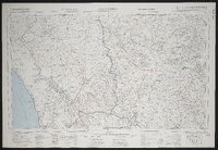
 3227DD Cambridge, South Africa 1:50000 sheet. Air photography 1938, 1954 and 1959. Surveyed and drawn in 1963 by the Trigonometrical Survey Office. Lugfotografie 1938, 1954 and 1959. Opgemeet en geteken in 1963 deur die Driehoeksmeting Kantoor. T.S.O. 200/2000. Cadastral information supplied by the Surveyor-General, Cape. Second edition,Second edition
 -
 3324 Port Elizabeth, South Africa 1:25000 sheet. Opgemeet in 1971 en geteken in 1972 deur die Direkteur-Generaal van Opmetings Kadastraal hersien 1974. Surveyed in 1971 and drawn in 1972 by the Director General of Surveys Cadastral revised 1974. T.S.O. 404/6646. Magisterial districts as at June 1975. Second edition.,Second
 -
 3324 Port Elizabeth, South Africa 1:25000 sheet. Compiled and drawn in 1960 by the Trigonometric Survey Office. Magisterial districts as at January 1964. T.S.O. 404/976. (Saamgestel en geteken in 1960 deur die Driehokesmatings Kantoor.)
 -
 3226AC Alicedale South Africa 1:50000 sheet. Air photography 1957. Field survey 1962. Drawn by the Trigonometric Survey in 1963. T.S.O. 200/1893. (Lugfotografie 1957. Veldopmeting 1962. Saamgestel en geteken in 1963 deur die Driehokesmatings Kantoor.) First edition
 -
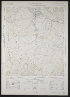
 3226BC Grahamstown South Africa 1:50000 sheet. Air photography 1949. Field survey 1958. Drawn by the Trigonometric Survey in 1964. T.S.O. 200/1464. (Lugfotografie 1949. Veldopmeting 1958. Saamgestel en geteken in 1964 deur die Driehokesmatings Kantoor.) First edition
 -
 3420 Riversdale, South Africa 1:25000 sheet. Compiled and drawn in 1960 by the Trigonometric Survey Office. Magisterial districts as at November 1960. T.S.O. 404/978. (Saamgestel en geteken in 1960 deur die Driehokesmatings Kantoor.)
 -
 A general plan of Cradock taken from the plans of surveyors Aling, Chiappini and Rorders by F.H. Hopley, 1851? Manuscript copy of original.
 -
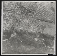 Photograph of Grahamstown from the air. Pretoria, Trigonometrical Survey Office, 1949.
 -
 3222 Beaufort West, South Africa 1:25000 sheet. Compiled and drawn in 1959 by the Trigonometric Survey Office. Magisterial districts as at November 1960. T.S.O. 404/968. (Saamgestel in 1960 en geteken in 1960 deur die Driehokesmatings Kantoor.)
 -
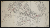 Master layout plan, showing layout of streets and the locations of schools, playing fields, shops, nursery schools, cinemas, clinics, nursing homes, garages, hotels, churches, government buildings, community centres, parks, nursing homes and the railway station. The map also shows the areas around Bethelsdorp including Chatty, Varsvlei, Missionvale, Gelanse, the S.A.N.T.A. hospital and surrounding area, sites for a university, a training college and a technical college as well as a saltpan and salt works. Designed by W.A. Smith. B-Y-9.
 -
 3022 Britstown, South Africa 1:25000 sheet. Compiled and drawn in 1961 by the Trigonometric Survey Office. Magisterial districts as at June 1961. T.S.O. 404/955. (Saamgestel in 1960 en geteken in 1961 deur die Driehokesmatings Kantoor.)
 -
 3118 Calvinia, South Africa 1:25000 sheet. Compiled and drawn in 1960 by the Trigonometric Survey Office. Magisterial districts as at February 1961. T.S.O. 404/960. (Saamgestel in 1960 en geteken in 1960 deur die Driehokesmatings Kantoor.)
 -
 City of Grahamstown electricity scheme; compiled in the City Electrical Engineer's office ; signed 11/3/32, J. Iverach.
 -
 3218 Clanwilliam, South Africa 1:25000 sheet. Compiled and drawn in 1960 by the Trigonometric Survey Office. Magisterial districts as at June 1967. T.S.O. 404/966. (Saamgestel en geteken in 1960 deur die Driehokesmatings Kantoor.)
 -
 3025 Colesberg, South Africa 1:25000 sheet. Compiled and drawn in 1959 by the Trigonometric Survey Office. Magisterial districts as at January 1964. T.S.O. 404/956. (Saamgestel in 1959 en geteken in 1959 deur die Driehokesmatings Kantoor.)
 -
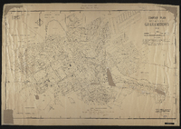 Contour plan of Grahamstown, 1934. Drawn by A.W.M. ; signed by W.A. Hodge, City Engineer. "War time regulations: this plan must not be removed from college premises under any circumstances" signed by E H Wied.
 -
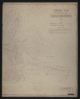 Contour plan of the City of Grahamstown; drawn by A.W.M. Checked by W.A. Hodge, June 1934
 -
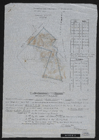 In the Division of Albany, Field Cornetcy of Lower Riebeek.
 -
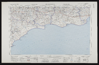
 3326 East London, South Africa 1:25000 sheet. Compiled and drawn in 1961 by the Trigonometric Survey Office. Magesterial districts as at November 1960. T.S.O. 404/977. (Saamgestel in 1960 en geteken in 1960 deur die Driehokesmatings Kantoor.)
 -
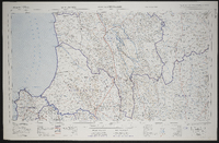
 3226 Fort Beaufort, South Africa 1:25000 topo-cadastral sheet, Suid Afrika 1 : 25000 topo-kadastrale vel, cadastral information supplied by the Surveyors General Office. TSO 404/970. Compiled and drawn in 1960 by the Trigonometrical Survey Office.
 -
 3226 Fort Beaufort, South Africa 1:25000 sheet. Compiled and drawn in 1960 by the Trigonometric Survey Office. Magisterial districts as at March 1965. T.S.O. 404/970. (Saamgestel en geteken in 1960 deur die Driehokesmatings Kantoor.)
 -
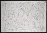
 3226 Fort Beaufort, South Africa 1:50000 topo-cadastral sheet, Suid Afrika 1 : 50000 topo-kadastrale vel, Kadastrale informasie verskaf deur die Landmeter-Generaal, Kaap. TSO 200/1737. Air photography 1949. Surveyed in 1961 and drawn in 1962 by the Trigonometrical Survey Office. Lugfotografie 1949. Opgemeet 1961 en geteken in 1962 deur die Driehoeksmeting Kantoor. First edition.
 -
 3224 Graaff-Reinet , South Africa 1:25000 sheet. Compiled and drawn in 1960 by the Trigonometric Survey Office. Magisterial districts as at July 1964. T.S.O. 404/969. (Saamgestel en geteken in 1960 deur die Driehokesmatings Kantoor.)
 -
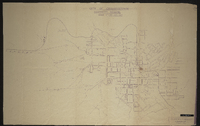
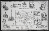 Street map of Grahamstown. This map was compiled and executed by Roy Haupt. [1965]. Printed by Cape and Transvaal Printers Ltd.