C.J. Skead Photograph Collection
Item set
- Title
- C.J. Skead Photograph Collection
- Creator
- Skead, C. J. (Cuthbert John)
- Description
-
The Jack (Cuthbert John) Skead Collection comprises a substantial body of photographic material that documents the natural environments, vegetation types, and ecological habitats of the Eastern Cape and the wider southern African region. The photographs—taken over several decades—capture landscapes, plant communities, wetlands, forests, grasslands, and other habitat formations that were central to Skead’s extensive research interests. Many images also document environmental change, land use patterns, and field sites associated with his ornithological and botanical studies.
The collection provides a valuable visual record for researchers working in the fields of environmental history, ecology, biogeography, conservation, and Eastern Cape natural heritage. The photographs complement Skead’s published and unpublished work held at Cory Library, including field notes, correspondence, and research manuscripts. - Language
- English
- Provenance
- Materials received from the Skead Family.
- Type
- Collection
- Genre
- Photographs
- Subject
- South Africa--Addo Elephant National Park
- Addo Elephant National Park (South Africa)
- Natual history -- South Africa -- Eastern Cape
- Vegetation -- South Africa -- Eastern Cape
- Habitats -- South Africa -- Eastern Cape
- Ecology -- South Africa -- Eastern Cape
- Landscape photography -- South Africa
- Photograph collections
- Environmental change -- South Africa -- Eastern Cape
- Biogeography -- South Africa
- Eastern Cape (South Africa) -- Photographs
- Albany District (South Africa) -- Photographs
- Skead, C. J. (Cuthbert John), 1912–2006
Items
-
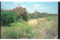
 A large exposed mound of sand (dune-like). Western entrance to Paterson village at Sand Flats (origionally Zand Vlakte) in the Alexandria district, 70 km NNE Port Elizabeth.
 -
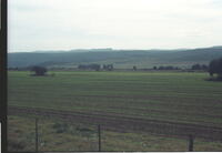 The highest ridge, once known as the Rietberg in the late 1700's and early 1800's, is now known only as the Suurberg, the old name Rietberg having fallen into total disuse. Looking north from 5 km west of Paterson (sandflats), Alexandria, towards the bushy-covered foothills of the Suurberg range (in near distance)
 -
 The highest ridge, once known as the Rietberg in the late 1700's and early 1800's, is now known only as the Suurberg, the old name Rietberg having fallen into total disuse. Looking across the bed of the Coerney River near Coerney towards the bush-covered foothills of the Suurberge with the long line of the open sourveld heights far behind.
 -
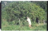
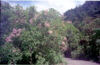
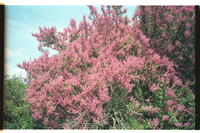
 Three fine specimens of Calpurnea aurea in full flower. Others out of picture.
 -
 Calpurnea aurea in full flower and seed. William Massyn collecting seed.
 -
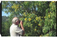 William Massyn photographing close-ups of Calpurnea aurea.
 -
 About 33 Milkwood trees, Sideroxylon inerme, survivors of severe bush-clearance for arable lands. Many dozens out of the picture. A remarkable aggregation. Dune bush in background.
 -
 More than 30 Milkwood trees, Sideroxylon inerme, survivors of severe bush-clearance for arable lands. Up to 200 such trees out of picture.
 -
 Nanqua's kop in distance taken from the southeast.
 -
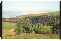 A misty Woody Cape and its dunes, the eastern end of Algoa Bay. Photo taken from the high coastal ridge east of Langebosch Forest.
 -
 Falcate yellowwood and surrounding forest.
 -
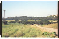
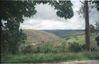
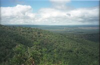 View from the Suurberg Pass looking south towards Coerney in right distance and the Addo Bush in left distance.
 -
 Calodendrum capensis in flower.
 -
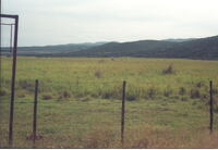
 Scene halfway up the Suurberg Pass, Alexandria district.
 -
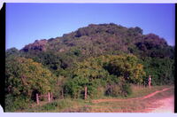
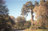
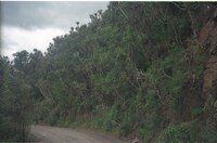
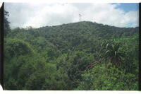 Forest scene halfway up the Suurberg Pass, Alexandria.
 -
 Taken from halfway up the Suurberg Pass.
 -
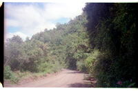
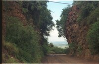 Road-cutting known as 'Die Kerf', halfway up Suurberg Pass near Coerney. From north entrance.
 -
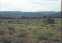
 Taken from about 3/4 way up Suurberg Pass.
 -
 View from Suurberg Inn at the top of Suurberg Pass looking north towards the Rietberg ridge now known as the Suurberg.
 -
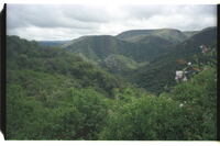
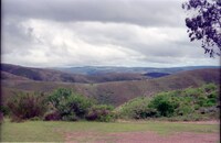 View northwestwards from near the Suurberg Inn above the Suurberg Pass.
 -
 Massed growth of tall Euphorbias in strong contrast to the verdant forests further up the same pass road.
 -
 With a year or more of weed-growth. A weir across the river is about 80m down river from the bridge.
 -
 Close-up of a single Spekboom tree Portulacaria afra, one of a whole countryside in full blossom.
 -
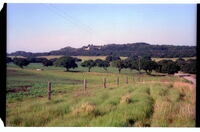
 Dense hedge of Spekboom, Portulacaria afra. Addo Elephant Park in background.