-
 Lower Elands River bushveld, Uitenhage
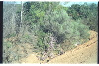
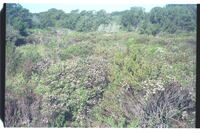
 ine single flowering specimen of Felicia filifolia, a very common species, surviving in harsh roadside conditions. A renosterbos, Elytropappus rhinocerotis (behind right) and a flowering Leonotis beyond.
-
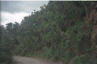
 Lower Elands River bushveld, Uitenhage
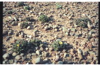
 14 plants of Faucaria sp. In the harshest possible conditions on bare stony ground, yet thriving. Many others on this same patch of ground. Photo taken at 14h00 with flowesr only just starting to open, early for this species which opens best at aboout 15h00, closing just before dusk.
-
 Lower Elands River Valley, Uitenhage
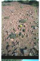
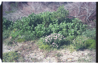
 Faucaria felina growing in dry, stony ground on 'Echodale' farm. Surrounded by dense bush.
-
 Lower Elands River Valley, Uitenhage district
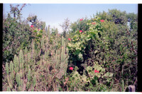
 Pelargonium inquinans in dense bushveld. Height of bush about 2.5 metres.
-
 Lower Elands River Valley, Uitenhage district
 Faucaria felina growing in dry, stony ground on 'Echodale' farm. Surrounded by dense bush.
-
 Lower Suurberg Pass near Coerney
 Massed growth of tall Euphorbias in strong contrast to the verdant forests further up the same pass road.
-
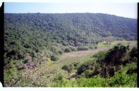 Maitland Forest (the former Landman's Bush) on lower De Stades River
 Maitland Forest (the former Landman's Bush) on lower De Stades River near confluence with the Maitland River. Looking upriver.
-
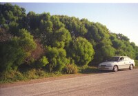 Marine Drive near Willows, Port Elizabeth
 Very tall growth of Rooikrans, A cyclops only 100m from the sea. Compare with other photos of heavily wind-cut rooikrans only 1.5km east of Willows but also 100m from the sea. Why the difference?
-
 Marine Drive, behind University of Port Elizabeth
 Fine example of Salvia africana-lutea.
-
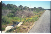 Marine Drive, behind University of Port Elizabeth
 Patch of Cape Weed Arctotheca calendula on roadside, one of many patches on this part of it. Recently felled wattles, part of campaign to give unemployed work, a futility in that the plants will coppice worse than ever.
-
 Marine Drive, behind University of Port Elizabeth
 Strong patch of Coleonema pulchrum plants showing how common the species is in this area.
-
 Marine Drive, near Noordhoek, Port Elizabeth
 Heavily windcut rooikrans, A cyclops 100m from the sea. Compare with tall rooikrans at The Willows 1.5km west of Noordhoek, also only 100m from the sea.
-
 Marine Drive, near Shelly Bay, Port Elizabeth
 Two plants of Felicia echinata at roadside. Other singletons were flowering elsewhere along this stretch of road.
-
 Michael Drive
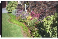
 Flowers in garden.
-
 Middle of Coega River Flats, 25km north Port Elizabeth central
 Fine lone Spekboom plant, Portulacaria afra with others in bush.
-
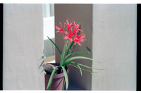 Miss HJ Vanderplank's stoep, 86 Kruger Gardens, Summerstrand, Port Elizabeth
 Cyrthanthus mortanus in pot.
-
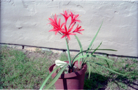 Miss HJ Vanderplank's stoep, 86 Kruger Gardens, Summerstrand, Port Elizabeth
 Cyrtanthus montanus in pot.
-
 Mount Misery between Coldspring and Atherstone, 10 km west of Grahamstown
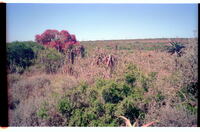
 Fine stand of Oldenburgia arbuscula on west slope. A denser stand crowned Mt. Misery instead before removal to accommodate a telephone-relay tower there in 1980's.
-
 Mount Thomas on the inner range of the Amathole Mountains between Hogsback to the west and Dohne Peak above Stutterheim to the east
 This whole range could well have been covered in both Protea subvestita and Protea multibracteata before being heavily overstocked with cattle. Even on the flats in the foreground relict patches of multibracteata occurred until the 1970's. Good populations of sugarbirds could therefore have existed.
-
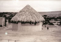 Mr. Harold Norton's farm 'Clifton', in the Grahamstown district
 The 'thatch' is made from the stems of Spekboom trees, Portulacaria afra. The dried stems are beaten with stones to flatten them, and are then packed on top of each other to form the thatch. There is no grassy thatching material in this dry Fish River area. No wonder the Spekboom is been destroyed so quickly.
-
 Municipal ground along east side of the Marine Drive near Noordhoek, Port Elizabeth
 Regrowth of duneveld (seven years regrowth) after fire of 14 jan 1998 when heavy invasions of wattle were destroyed. Note the bushy wattle regrowth among local indigenous vegetation.
-
 N. Border of Grassridge, Uitenhage
 Valley bush with Rhigozum obovatum at what must be its southernmost point of distribution here. More in flower elsewhere to the Suurberge after good winter rains.
-
 N2 on high ground of right bank of Nazaar River, 5km west of Sevenfountains and 28km SW of Grahamstown, Albany
 Patch of Erica nemorosa. Beyond road fences plant does not cope.
-
 N2 on high ground of right bank of Nazaar River, 5km west of Sevenfountains and 28km SW of Grahamstown, Albany
 Patch of Erica nemorosa. Beyond road fences plant does not cope.
-
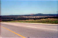 National Road out of Koega River above Salt Pans
 Coega Kops From South East across Coega River valley on National Road out of Coega River. Witteklip mountain in the distance.