-
 Loerie Reserve, Port Elizabeth
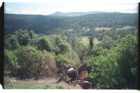
 PW Coetzee looking at Weaverbird nests at the large wildbird-cage enclosing the natural vegetation. Built to allow young children to get 'the feel' of the bush and the birds in it.
-
 Loerie River passing under low-water bridge into Loerie Reserve
 Much alien tree growth on the banks.
-
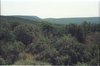
 Look-out picnis site of Van Staden's Wild Flower Reserve, Port Elizabeth
 On eastern lip of the deep valley down to the river. Fine specimen of Teerhout tree, Loxostylis alata centrally, one of several others there.
-
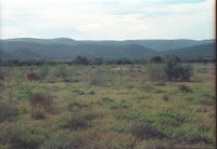
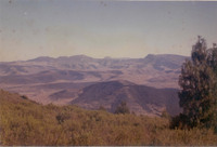
 Looking across the bed of the Coerney River near Coerney towards the bush-covered foothills of the Suurberge
 The highest ridge, once known as the Rietberg in the late 1700's and early 1800's, is now known only as the Suurberg, the old name Rietberg having fallen into total disuse. Looking across the bed of the Coerney River near Coerney towards the bush-covered foothills of the Suurberge with the long line of the open sourveld heights far behind.
-
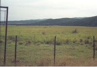
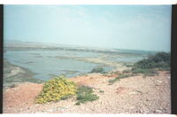
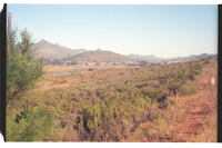
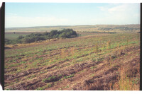 Looking across the eastern sector of the Quaggasvlakte just south of Paterson sandflats, Alexandria
 Preston Park farmstead in trees at top right. Once the home of Eland, hartebeest, true quagga, springbok, ostriches, etc. The beautiful grazing is now ripped up to produce wheat.
-
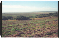 Looking across the eastern sector of the Quaggasvlakte just south of Paterson sandflats, Alexandria towards Bushman's River
 Once the home of Eland, hartebeest, true quagga, springbok, ostriches, etc. The beautiful grazing is now ripped up to produce wheat.
-
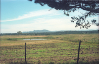 Looking across the Greenhouse Flats, west of Port Elizabeth to Witteklip Mt
 Photo taken after heavy rains, hence standing water. The dank vegetation across mid-picture is wattle encroachment. Up to the 1920's / 30's the flats to Witteklip were open fynbosveld almost in its prime.
-
 Looking across the Keiskamma basin from West Pirie Peak (Hoho Peak) to the three Hogsback peaks. To the left Bhukazana, centre Nguku (flat-top) and Mnyameni to the right
 Between these three and Chata Peak to the far right is Gaika's Kop, a truncated spitskop in the distance. On the slopes of Bhukazana a dense tall growth of Protea subvestita thrives as it does out of the picture to the immediate left of the photographer.
-
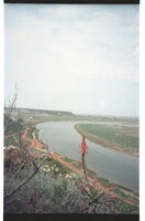 Looking along eastern escarpment of Swartkops River
 Looking from eastern escarpment of Swartkops River across lagoons towards Redhouse on the Swartkops River, westwards to the eastern escarpmant.
-
 Looking along eastern escarpment of Swartkops River towards Swartkops village
 Looking along eastern escarpment of Swartkops River towards Swartkops village.
-
 Looking down from the top of Highlands mountain to the homestead on Carl's Rust farm far below, and the upper Kariega Valley
 In the foreground are massed rushes (biesies) of Bobartia (Ncaluka, Xhosa - sometimes called whip reed).
-
 Looking down into the 'Rietfontein' amphitheatre on a tributary leading to Van Staden's River mouth
 Witteklip Mountain in background. 18th century waggoners rested here on farm of Muller before proceeding eastwards.
-
 Looking down on the lower reaches of uMthaleni Valley, Kei Road, King William's Town
 The Scaly-throated Honeyguides call-site was in the dense tall patch in the stream bed.
-
 Looking east over Wolwefontein, Steytlerville
 Where in 1797 John Barrow found 14 buffalos wallowing in a vlei and watched them run off into the hills.
-
 Looking north from 5 km west of Paterson (sandflats), Alexandria
 The highest ridge, once known as the Rietberg in the late 1700's and early 1800's, is now known only as the Suurberg, the old name Rietberg having fallen into total disuse. Looking north from 5 km west of Paterson (sandflats), Alexandria, towards the bushy-covered foothills of the Suurberg range (in near distance)
-
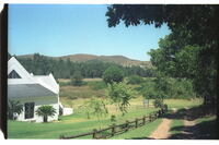
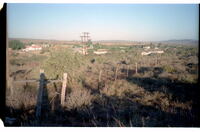
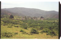
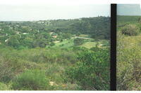
 Looking north to the Suurberg Enon village
 Looking north to the Suurberg Enon village (founded 1816) on the Witte River under the foothills between Coerney & Kirkwood.
-
 Looking northwards from Steylerville Road, Uitenhage
 Cluster of flowering Strelitzia juncea in dense Valley Bush now being used as a game farm, e.g. for kudu-hunting. Many other such clusters in the vicinity.
-
 Looking northwards up the Witte River to Enon village, Uitenhage, with the Suurberg in the background
 Looking down at Enon Mission in valley.
-
 Looking over Galgenbosch site (Thornhill)
 Now covered in alien trees towards the Van Staden's berg from the slopes leading to the Karoo to the south.
-
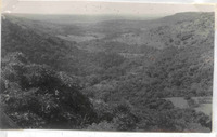
 Looking over Tweerivieren, Langkloof, Uniondale, not far east of Joubertina
 Looking over Tweerivieren, Langkloof, Uniondale, not far east of Joubertina.
-
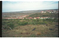 Looking south over desecrated Swartkops River valley towards the old Cradock Place (Papenkuilsfontein) from kwaMagxaki Hill
 Nice houses in centre photo overlooking urban sprawl beyond. Bethelsdorp Saltpan near top of photo, thinned out original veld in foreground in which Sanseviera plants thrive. More good type homes behind photographer.
-
 Looking southeast from top of easternmost Coega Kop over low bushy ground towards the Coega River mouth (indicated by a gap in the horizon hills, a distance of 6km)
 All this around will disappear under factory development with the proposed development of a harbour at Coega River mouth.
-
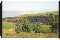 Looking towards Algoa Bay
 A misty Woody Cape and its dunes, the eastern end of Algoa Bay. Photo taken from the high coastal ridge east of Langebosch Forest.
-
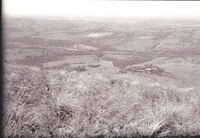
 Looking up Baakens River Valley, Port Elizabeth, from Wellington Park on right bank
 Target Kloof road centrally with Settler's Park Reserve in valley bottom in right centre of photo.