Skip to main content
Pre 1910 Maps
Items
-
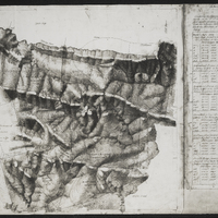
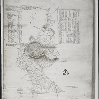
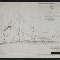 Sketch map shewing the route of the mission under the change of Captain Delancy, 75th Regt. to the chiefs Creli - the successor to Hintza - Vadana of the Tambookies and Faku of the Amapondas in 1836 - also the grant (coloured green) by Crieli to the British
-
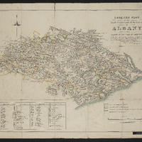
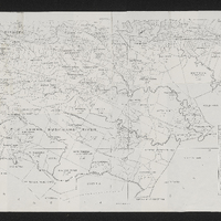 Divisional map of Albany
-
 The district of Albany, formerly t'Zuureveld
-
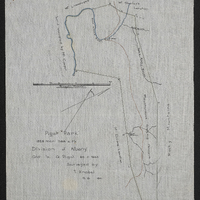 "Pigot Park" : 1828 mor 388 s. rs ; Division of Albany, Gtd to G.Pigot, 20.11.1823
-
 General plan : comprising the following farms, resurveyed under the provisions of the Land Beacons Act situate in the Fd. Cy. of Assegaai Bush, Division of Albany and having the dimensions and relative positions quoted below and shown in the drawing, the co-ordinates being reckoned from the Reference Stone Market Square, Grahamstown, and the bearings being from parallels to the meridian of Driver's Hill [127.56 N. 4262.22 E.] as given by Capt Bailey in his coast survey
-
 Diagram of a part of the cancelled loan farm Assegaai Bush situated in that part of the disctrict of Uitenhage called Albany
-
 Plan of a portion of the Kei Garip or Great Orange River, extending from Eis to Pella Mission Station and forming the Northern frontier of the Colony : constructet from observations made during a journey from Little Namaqualand to Kuruman in October 1856...
-
 Map of Little Namaqualand and Great Bushmanland together, otherwise known as the terribory annexed to the Colony by proclamation of 17 December 1847 shewing the portions yet unexplored, the borders of the subdivided districts, the native locations and missions, the mining locality and the author's route from Colesburg to Steinkopf
-
 Sketch shewing the sites and relative positions of Ordinance and other Government works constructed in British Kaffraria (incl. notes on the construction of new posts and and distribution of troops at the posts) ; taken from a survey by Capt. Tylden by Chas J. Fawler, R.W., LieutRoyal Engineers, 26th Sept. 1853.
-
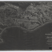
 General plan of the South Eastern part of the district of Albany in the Colony of the Cape of Good Hope shewing the situation and exact boundaries of the lands allotted for the location of English Settlers as also towns, military and other establishments , personal grants of lands etc.
-
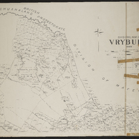 Divisional map of Vryburg
-
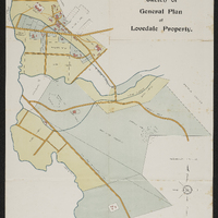 Sketch of general plan of Lovedale property
-
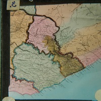
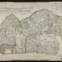 Plan of territories formerly known as Kaffraria proper, lying between the following boundaries, the Quathlamba range on the north, the sea coast on the east, Natal on the north east and the Kei and Indwe on south west
-
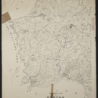 Divisional Map of Komgha
-
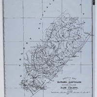 Sketch Map of Kafraria, Basutoland and the eastern frontier of the Cape Colony
-
 Sketch of proposed extension of the Gaika boundary from a sketch by Major Tylden, Royal Eng.
-
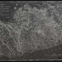
 Sketch map of the country between the Kowie and the Chalumna Rivers showing the Fingo and Kafir locations, general lay of the country etc
-
 Map of Eastern Province showing Province of Queen Adelaide
-
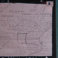 Map of Africa, 1794. Estate of Monomotapa
-
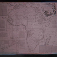 Map of Africa, 1794